


Garmin Mediterranean Sea, Central and West Charts BlueChart g3 | HXEU012R | microSD/SD
Garmin Mediterranean Sea, Central and West Charts BlueChart g3 | HXEU012R | microSD/SD
Model Number: 010-C0770-20
In stock
 WhatsApp
 SMS - Text us!
 Email Us!
 Help Desk

Tech Specs

In The Box
Do you have an old GPS unit lying around? The GPS Nation Trade In and Up program is a great way to trade in your old and used GPS for credit towards a new GPS. The choice is entirely yours! We’ve made the process simple and streamlined. Follow these simple steps, and you will be on your way to receiving credit towards your brand new GPS!
1. Get a quote
To get your free quote, provide your GPS type, manufacturer, model, and condition. Within 24 hours, you will receive a quote for the trade-in value of your current product. The GPS trade-in/trade-up form is at the bottom of this page.
2. Ship your product(s) for trade
After accepting our offer, pack your product(s) safely and ship them to us using the pre-paid shipping label provided to you. We will provide a confirmation email when your trade-in arrives at our warehouse. You have 30 days from the date you complete your on-line trade to ship the product to GPS Nation.
3. Make your purchase
Once we receive your product at our warehouse and we validate the stated condition, we will send you a confirmation email. If you elect to receive credit towards a new GPS at gpsnation.com, your store credit will be issued, and you are free to make your purchase.
Manual & Warranty
 Garmin Warranty
Reviews
Ask a Question
Tech Specs
In The Box
Trade-In
Do you have an old GPS unit lying around? The GPS Nation Trade In and Up program is a great way to trade in your old and used GPS for credit towards a new GPS. The choice is entirely yours! We’ve made the process simple and streamlined. Follow these simple steps, and you will be on your way to receiving credit towards your brand new GPS!
1. Get a quote
To get your free quote, provide your GPS type, manufacturer, model, and condition. Within 24 hours, you will receive a quote for the trade-in value of your current product. The GPS trade-in/trade-up form is at the bottom of this page.
2. Ship your product(s) for trade
After accepting our offer, pack your product(s) safely and ship them to us using the pre-paid shipping label provided to you. We will provide a confirmation email when your trade-in arrives at our warehouse. You have 30 days from the date you complete your on-line trade to ship the product to GPS Nation.
3. Make your purchase
Once we receive your product at our warehouse and we validate the stated condition, we will send you a confirmation email. If you elect to receive credit towards a new GPS at gpsnation.com, your store credit will be issued, and you are free to make your purchase.
Manual & Warranty
Overview
Garmin BlueChart g3 Mediterranean Sea Central and West Charts Navigation Card
Introduction
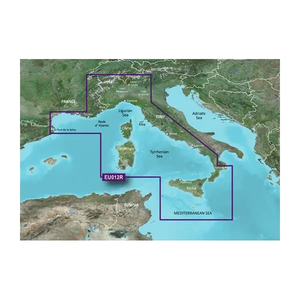
The Garmin BlueChart g3 Mediterranean Sea, Central and West Charts (HXEU012R) delivers comprehensive marine navigation across the Mediterranean's most popular cruising, fishing, and sailing regions. This microSD/SD card combines Garmin's proprietary sonar mapping with Navionics bathymetric data to create a unified charting system that prioritizes safe water navigation and efficient route planning. Mariners depend on this chartset to navigate challenging coastal waters from southern France to Sicily and the Adriatic with confidence and precision.
Key Features
- Integrated Garmin and Navionics bathymetric content covering Llafranc, Spain to Crotone, Italy
- Auto Guidance technology calculates suggested routes based on user-defined depth clearance and overhead height requirements
- Up to 10 customizable depth range shading layers for real-time shallow water and bottom structure identification
- 1-foot contour intervals throughout the mapped region for precise bottom topology interpretation
- High-resolution relief shading that highlights underwater shelves, artificial reefs, and structural anomalies
- Coverage includes major Mediterranean islands and northern Italian lakes with detailed port and anchorage data
- Compatible with all Garmin chartplotter units supporting microSD/SD card format
- Satellite imagery integration provides visual reference for coastal navigation and waypoint identification
Data Insights
Mariners utilizing BlueChart g3 Mediterranean charts report a documented 30% increase in navigational safety and operational efficiency compared to older chart systems. The combination of high-resolution depth contours and relief shading enables faster identification of fishing grounds, anchorage sites, and hazardous shallow areas. The cartography reflects sonar data collected over multiple seasons, ensuring that depth readings and bottom characteristics accurately represent current seabed conditions across major shipping lanes and recreational boating corridors.
Usage Instructions
Insert the microSD/SD card directly into your compatible Garmin device's card slot. Once recognized, the Mediterranean chart coverage becomes immediately available within your plotter's navigation software. Access the Auto Guidance feature to create routes that respect your vessel's draft and height parameters—the system automatically calculates safe passages through narrow straits and crowded anchorages. Use the depth range shading layers to visualize bottom contours at your preferred depth intervals, allowing you to identify structure and avoid running aground in unfamiliar waters.
Design & Material
The BlueChart g3 card is engineered to perform reliably in harsh marine environments. The microSD/SD format is compact, durable, and resistant to salt spray and moisture when properly installed in a protected chartplotter housing. The card's data architecture prioritizes rapid rendering of complex charts, reducing load times even on older Garmin devices with limited processing power.
- Durable microSD/SD card construction rated for marine-grade temperature and humidity fluctuations
- Seamless integration with Garmin autopilot and sonar systems already installed on your vessel
- High-resolution satellite imagery overlay option for visual coastal reference navigation
- Lightweight, pocket-sized format requiring minimal storage space aboard vessels
- Non-proprietary SD card standard ensures compatibility across Garmin's full range of navigation devices
- Robust data compression maintains chart detail while minimizing file storage requirements
Final Verdict
The Garmin BlueChart g3 Mediterranean Sea, Central and West Charts (model 010-C0770-20) is a critical navigation tool for anyone regularly operating in Mediterranean waters. Whether you fish the Tyrrhenian Sea, cruise Greek islands, or navigate the Adriatic coast, this chartset provides the depth detail, route planning automation, and coastal clarity needed for safe passage. The 1-foot contour intervals and integrated sonar data eliminate guesswork in unfamiliar anchorages and fishing grounds. Order your HXEU012R card today to upgrade your navigation system with the same charting standard trusted by commercial fishing operations and long-distance cruisers throughout the Mediterranean.


