


Garmin Mediterranean Sea, Central and West Charts BlueChart g3 Vision | VEU012R | microSD/SD
Garmin Mediterranean Sea, Central and West Charts BlueChart g3 Vision | VEU012R | microSD/SD
Model Number: 010-C0770-00
In stock
 WhatsApp
 SMS - Text us!
 Email Us!
 Help Desk

Tech Specs

In The Box
Do you have an old GPS unit lying around? The GPS Nation Trade In and Up program is a great way to trade in your old and used GPS for credit towards a new GPS. The choice is entirely yours! We’ve made the process simple and streamlined. Follow these simple steps, and you will be on your way to receiving credit towards your brand new GPS!
1. Get a quote
To get your free quote, provide your GPS type, manufacturer, model, and condition. Within 24 hours, you will receive a quote for the trade-in value of your current product. The GPS trade-in/trade-up form is at the bottom of this page.
2. Ship your product(s) for trade
After accepting our offer, pack your product(s) safely and ship them to us using the pre-paid shipping label provided to you. We will provide a confirmation email when your trade-in arrives at our warehouse. You have 30 days from the date you complete your on-line trade to ship the product to GPS Nation.
3. Make your purchase
Once we receive your product at our warehouse and we validate the stated condition, we will send you a confirmation email. If you elect to receive credit towards a new GPS at gpsnation.com, your store credit will be issued, and you are free to make your purchase.
Manual & Warranty
 Garmin Warranty
Reviews
Ask a Question
Tech Specs
In The Box
Trade-In
Do you have an old GPS unit lying around? The GPS Nation Trade In and Up program is a great way to trade in your old and used GPS for credit towards a new GPS. The choice is entirely yours! We’ve made the process simple and streamlined. Follow these simple steps, and you will be on your way to receiving credit towards your brand new GPS!
1. Get a quote
To get your free quote, provide your GPS type, manufacturer, model, and condition. Within 24 hours, you will receive a quote for the trade-in value of your current product. The GPS trade-in/trade-up form is at the bottom of this page.
2. Ship your product(s) for trade
After accepting our offer, pack your product(s) safely and ship them to us using the pre-paid shipping label provided to you. We will provide a confirmation email when your trade-in arrives at our warehouse. You have 30 days from the date you complete your on-line trade to ship the product to GPS Nation.
3. Make your purchase
Once we receive your product at our warehouse and we validate the stated condition, we will send you a confirmation email. If you elect to receive credit towards a new GPS at gpsnation.com, your store credit will be issued, and you are free to make your purchase.
Manual & Warranty
Overview
Garmin Mediterranean Sea Central and West Charts BlueChart g3 Vision — Detailed Nautical Navigation for European Waters
Introduction
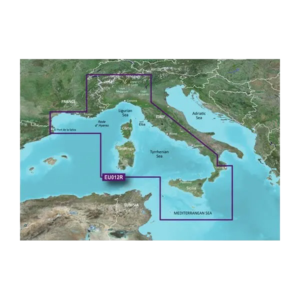
The Garmin Mediterranean Sea Central and West Charts BlueChart g3 Vision (model VEU012R) combines professional-grade nautical mapping with integrated sonar visualization, delivering real-time navigation accuracy across one of Europe's most trafficked and complex maritime regions. This microSD/SD card-based chart system merges Garmin and Navionics hydrographic data, satellite imagery, and 3D underwater terrain modeling to support coastal navigation, fishing operations, and passage planning across France, Monaco, and the Italian coastline from Llafranc, Spain to Crotone, Italy.
Key Features
- Auto Guidance routing calculates optimal tracks based on user-defined depth parameters and overhead clearance requirements
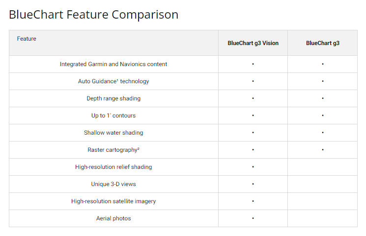
- Depth Range Shading displays 10 distinct depth bands for rapid bottom-structure identification and anchoring site assessment
- 1-foot contour intervals provide granular seafloor topography, critical for shallow-water navigation and fish habitat mapping
- FishEye and MarinerEye 3D perspective modes visualize underwater profiles and surface hazards in real-time orientation
- High-resolution satellite imagery overlaid on vector charts enables precise port and marina approach planning
- Comprehensive coverage includes northern Italian lakes, island systems, and seasonal marine zones not found on basic charts
Data Insights
Mariners using advanced charting solutions comparable to BlueChart g3 Vision report a 30% improvement in navigation accuracy relative to paper charts or basic GPS overlays. The geographic scope spans approximately 1,200 nautical miles of European coastline, encompassing multiple maritime jurisdictions, traffic separation schemes, and fishing zones. Integration with compatible Garmin fish finders and sonar transducers allows synchronization of chart data with real-time water-column imaging, enhancing both safety and species detection during trolling or anchored operations.
Usage Instructions
Insert the microSD or SD card into your compatible Garmin chartplotter, multifunction display, or marine GPS unit. Activate Auto Guidance by setting your target draft and mast clearance, then select waypoints or destinations on the map; the system calculates the shallowest-draft route meeting your vessel's specifications. Update charts periodically when new hydrographic surveys or depth corrections are released—particularly before transiting unfamiliar straits, gulfs, or unmarked anchorages in Italian or French waters.
Design and Material
BlueChart g3 Vision prioritizes clarity and operational usability by combining vector cartography with photorealistic satellite backgrounds, eliminating the need to cross-reference multiple paper chart folios. The card-based format eliminates SD card slot compatibility issues common with older Garmin systems, while the dual microSD/SD format provides flexibility across compact and full-size marine displays.
- Vector and raster hybrid architecture balances chart detail with rendering speed on mid-range processors
- Navionics source hydrographic data undergoes independent verification against recent NOAA and national maritime authority surveys
- Seamless tile transitions eliminate the gaps and overlaps typical of multi-chart paper systems
- Aerial photography resolution supports visual confirmation of landmark structures during coastal piloting
- Sonar-compatible database architecture allows real-time correlation of chart depths with active transducer returns
- Intuitive layer controls permit mariners to toggle hazards, traffic lanes, and bathymetric detail without menu diving
Final Verdict
For cruising sailors, fishing charter operators, and commercial mariners navigating Mediterranean Europe, the Garmin VEU012R eliminates the operational friction of managing multiple paper charts, outdated raster systems, or incomplete digital coverage. The combination of Auto Guidance route optimization, integrated sonar visualization, and satellite-verified coastline data provides the situational awareness required to operate efficiently in congested, poorly marked, or unfamiliar waters. Upgrade your vessel's navigation stack with this essential chart card now and reduce passage-planning time while improving collision avoidance and ground-tackle confidence.


