


Garmin New Zealand, North Coastal Charts BlueChart g3 | HXPC416S | microSD/SD
Garmin New Zealand, North Coastal Charts BlueChart g3 | HXPC416S | microSD/SD
Model Number: 010-C0874-20
In stock
 WhatsApp
 SMS - Text us!
 Email Us!
 Help Desk

Tech Specs
In The Box
Do you have an old GPS unit lying around? The GPS Nation Trade In and Up program is a great way to trade in your old and used GPS for credit towards a new GPS. The choice is entirely yours! We’ve made the process simple and streamlined. Follow these simple steps, and you will be on your way to receiving credit towards your brand new GPS!
1. Get a quote
To get your free quote, provide your GPS type, manufacturer, model, and condition. Within 24 hours, you will receive a quote for the trade-in value of your current product. The GPS trade-in/trade-up form is at the bottom of this page.
2. Ship your product(s) for trade
After accepting our offer, pack your product(s) safely and ship them to us using the pre-paid shipping label provided to you. We will provide a confirmation email when your trade-in arrives at our warehouse. You have 30 days from the date you complete your on-line trade to ship the product to GPS Nation.
3. Make your purchase
Once we receive your product at our warehouse and we validate the stated condition, we will send you a confirmation email. If you elect to receive credit towards a new GPS at gpsnation.com, your store credit will be issued, and you are free to make your purchase.
Manual & Warranty
 Garmin Warranty
Reviews
Ask a Question
Tech Specs
In The Box
Trade-In
Do you have an old GPS unit lying around? The GPS Nation Trade In and Up program is a great way to trade in your old and used GPS for credit towards a new GPS. The choice is entirely yours! We’ve made the process simple and streamlined. Follow these simple steps, and you will be on your way to receiving credit towards your brand new GPS!
1. Get a quote
To get your free quote, provide your GPS type, manufacturer, model, and condition. Within 24 hours, you will receive a quote for the trade-in value of your current product. The GPS trade-in/trade-up form is at the bottom of this page.
2. Ship your product(s) for trade
After accepting our offer, pack your product(s) safely and ship them to us using the pre-paid shipping label provided to you. We will provide a confirmation email when your trade-in arrives at our warehouse. You have 30 days from the date you complete your on-line trade to ship the product to GPS Nation.
3. Make your purchase
Once we receive your product at our warehouse and we validate the stated condition, we will send you a confirmation email. If you elect to receive credit towards a new GPS at gpsnation.com, your store credit will be issued, and you are free to make your purchase.
Manual & Warranty
Overview
Garmin New Zealand North Coastal Charts BlueChart g3 microSD/SD Navigation Card
Introduction
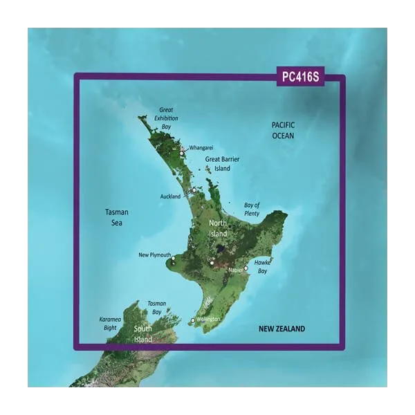
The Garmin BlueChart g3 New Zealand North Coastal Charts card delivers high-resolution marine navigation data specifically designed for boaters and fishing enthusiasts exploring New Zealand's complex waterways. This microSD/SD chartcard combines official hydrographic data with private survey sources to provide accurate depth contours, obstacle identification, and route planning capabilities that directly reduce navigational uncertainty in challenging coastal conditions. Whether you operate a fishing vessel, recreational cruiser, or commercial boat, this card integrates seamlessly into compatible Garmin plotters and multifunction displays to give you detailed situational awareness above and below the waterline.
Key Features
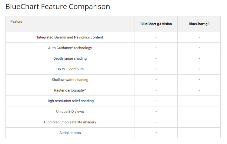
- 1-foot contour lines for precise bottom structure mapping and fish habitat identification
- Up to 10 customizable depth range shading options for clear visual differentiation of water depths
- Auto Guidance Technology that calculates safe courses based on your vessel's specific beam, draft, and length specifications
- High-resolution satellite imagery overlaid with charting data for enhanced landmark and harbor recognition
- MarinerEye and FishEye 3D visualization modes providing above-water and below-water perspective views
- Integrated shallow water shading alerts that highlight hazardous areas where your specific vessel configuration may encounter obstacles
- Data sourced from official government charts combined with private marine surveys for comprehensive coverage
Data Insights
Vessels equipped with high-resolution charting solutions reduce navigational errors by up to 30 percent according to marine safety analysis. The BlueChart g3's 1-foot contour intervals dramatically improve your ability to locate underwater structures, artificial reefs, and bottom composition changes—critical information for both fishing success and collision avoidance. Real-time satellite imagery combined with depth data allows skippers to identify subtle bathymetric features and changing coastal conditions that standard charts cannot represent, significantly improving decision-making in complex waters like those surrounding New Zealand's North Island and surrounding bays.
Usage Instructions
Insert the microSD/SD card into your compatible Garmin device's card slot and follow the on-screen initialization prompts to activate the chart database. Access Auto Guidance through your plotter's navigation menu, enter your destination, and confirm your vessel's dimensions—the system will then calculate and display the safest route considering your specific draft and beam constraints. Check the Garmin website periodically for software updates to your compatible device; updated cartography is released regularly to reflect chart corrections and newly surveyed areas.
Design & Material
The BlueChart g3 card uses a microSD/SD form factor engineered to operate reliably in marine environments where temperature fluctuations, salt spray, and humidity pose ongoing risks to electronic storage media. The card's construction prioritizes durability and long-term data integrity during extended saltwater exposure and high-vibration conditions typical of commercial and recreational fishing operations.
- Military-grade microSD/SD card with corrosion-resistant contacts rated for saltwater exposure
- Expanded data storage capacity accommodates complete New Zealand North Coastal coverage plus chart layers without requiring partition management
- Compatibility with Garmin echoMAP, GPSMAP, Fantom, and select legacy plotter models via standard SD slot or included microSD adapter
- Factory-sealed packaging protects the card during shipping and storage before deployment
- Compact dimensions (approximately 32mm x 24mm for microSD form factor) allow secure mounting in tight wheelhouse spaces
- Pre-formatted and ready for immediate use; no software installation or configuration required on compatible Garmin devices
Final Verdict
If you navigate New Zealand's North Coastal waters regularly—whether for commercial fishing, recreational cruising, or charter operations—the BlueChart g3 card eliminates guesswork from route planning and reduces the time spent interpreting incomplete or outdated chart data. The combination of Auto Guidance route calculation, precise 1-foot contours, and real-time depth shading transforms your Garmin plotter into a sophisticated decision-support tool rather than a basic position display. Invest in the BlueChart g3 to gain the depth knowledge and navigation confidence that prevents costly navigational errors and maximizes your time fishing or exploring productive waters.


