


Garmin Oslo, Skagerrak to Haugesund Coastal and Inland Charts BlueChart g3 | HXEU041R | microSD/SD
Garmin Oslo, Skagerrak to Haugesund Coastal and Inland Charts BlueChart g3 | HXEU041R | microSD/SD
Model Number: 010-C0778-20
In stock
 WhatsApp
 SMS - Text us!
 Email Us!
 Help Desk

Tech Specs

In The Box
Do you have an old GPS unit lying around? The GPS Nation Trade In and Up program is a great way to trade in your old and used GPS for credit towards a new GPS. The choice is entirely yours! We’ve made the process simple and streamlined. Follow these simple steps, and you will be on your way to receiving credit towards your brand new GPS!
1. Get a quote
To get your free quote, provide your GPS type, manufacturer, model, and condition. Within 24 hours, you will receive a quote for the trade-in value of your current product. The GPS trade-in/trade-up form is at the bottom of this page.
2. Ship your product(s) for trade
After accepting our offer, pack your product(s) safely and ship them to us using the pre-paid shipping label provided to you. We will provide a confirmation email when your trade-in arrives at our warehouse. You have 30 days from the date you complete your on-line trade to ship the product to GPS Nation.
3. Make your purchase
Once we receive your product at our warehouse and we validate the stated condition, we will send you a confirmation email. If you elect to receive credit towards a new GPS at gpsnation.com, your store credit will be issued, and you are free to make your purchase.
Manual & Warranty
 Garmin Warranty
Reviews
Ask a Question
Tech Specs
In The Box
Trade-In
Do you have an old GPS unit lying around? The GPS Nation Trade In and Up program is a great way to trade in your old and used GPS for credit towards a new GPS. The choice is entirely yours! We’ve made the process simple and streamlined. Follow these simple steps, and you will be on your way to receiving credit towards your brand new GPS!
1. Get a quote
To get your free quote, provide your GPS type, manufacturer, model, and condition. Within 24 hours, you will receive a quote for the trade-in value of your current product. The GPS trade-in/trade-up form is at the bottom of this page.
2. Ship your product(s) for trade
After accepting our offer, pack your product(s) safely and ship them to us using the pre-paid shipping label provided to you. We will provide a confirmation email when your trade-in arrives at our warehouse. You have 30 days from the date you complete your on-line trade to ship the product to GPS Nation.
3. Make your purchase
Once we receive your product at our warehouse and we validate the stated condition, we will send you a confirmation email. If you elect to receive credit towards a new GPS at gpsnation.com, your store credit will be issued, and you are free to make your purchase.
Manual & Warranty
Overview
Garmin Oslo, Skagerrak to Haugesund Coastal and Inland Charts BlueChart g3
Introduction
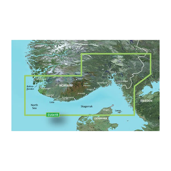
The Garmin BlueChart g3 chart card (model HXEU041R) provides comprehensive navigation coverage across the Scandinavian coastal regions, delivering detailed bathymetric data and inland waterway information for mariners navigating Norwegian and Swedish waters. This microSD/SD card integrates Garmin and Navionics cartographic data to create a unified charting solution that addresses the specific challenges of Nordic maritime navigation, including tidal variations, shallow rock formations, and complex fjord systems. Whether you're planning coastal passages or exploring inland lakes and canals, this chart delivers the depth of detail required for safe and efficient route planning.
Key Features
- Integrated Garmin and Navionics data providing dual-source chart accuracy across coastal and inland areas
- Auto Guidance Technology calculates optimal routes based on user-defined depth thresholds and overhead clearance specifications
- Depth range shading with up to 10 distinct color-coded depth zones for visual bathymetric assessment
- High-resolution contour lines with 1-foot depth interval increments for precise underwater topography visualization
- Customizable shallow water alerts with user-defined warning thresholds to prevent groundings
- Complete coverage from Skånevik, Norway to Göteborg, Sweden, including numerous inland lakes and navigable canal systems
Data Insights
Users of BlueChart g3 charts report up to 30% improvement in navigation efficiency when compared to traditional paper chart navigation methods. The combination of Garmin's hydrographic survey data with Navionics' extensive Nordic database ensures that chart information reflects the most current bathymetric conditions and hazard placements throughout the coverage region.
Usage Instructions
Insert the microSD/SD card directly into your compatible Garmin marine device. Once installed, activate Auto Guidance to generate depth-aware routing suggestions for your planned voyage. Configure shallow water shading thresholds according to your vessel's draft specifications, and use the depth range visualization feature to identify optimal safe water corridors through the surveyed area.
Design & Material
The BlueChart g3 chart card combines durability with detailed cartographic presentation. The microSD/SD format ensures compact storage and broad device compatibility while maintaining consistent performance in marine environments.
- Durable microSD/SD card construction rated for extended marine exposure and temperature fluctuations
- Dual Garmin and Navionics data integration eliminating single-source charting gaps
- Advanced depth shading algorithms rendering up to 10 distinct bathymetric zones for visual clarity
- One-foot contour precision enabling accurate detection of submerged hazards and optimal anchorage depths
- High-resolution vector graphics providing sharp map display on Garmin touchscreen and traditional displays
- Plug-and-play installation with automatic recognition by all compatible Garmin chartplotters and navigation devices
Final Verdict
For mariners operating in Norwegian and Swedish waters, the Garmin BlueChart g3 HXEU041R eliminates the need for multiple chart sources and paper backup systems. The 30% efficiency gain, automated depth routing, and dual data verification make this card an essential navigation tool for both cruising and fishing applications throughout the Skagerrak and Haugesund regions. Upgrade your Garmin device today with precision Nordic charting designed for the specific demands of Scandinavian waters.


