


Garmin Oslo, Skagerrak to Haugesund Coastal and Inland Charts BlueChart g3 Vision | VEU041R | microSD/SD
Garmin Oslo, Skagerrak to Haugesund Coastal and Inland Charts BlueChart g3 Vision | VEU041R | microSD/SD
Model Number: 010-C0778-00
In stock
 WhatsApp
 SMS - Text us!
 Email Us!
 Help Desk

Tech Specs
In The Box
Do you have an old GPS unit lying around? The GPS Nation Trade In and Up program is a great way to trade in your old and used GPS for credit towards a new GPS. The choice is entirely yours! We’ve made the process simple and streamlined. Follow these simple steps, and you will be on your way to receiving credit towards your brand new GPS!
1. Get a quote
To get your free quote, provide your GPS type, manufacturer, model, and condition. Within 24 hours, you will receive a quote for the trade-in value of your current product. The GPS trade-in/trade-up form is at the bottom of this page.
2. Ship your product(s) for trade
After accepting our offer, pack your product(s) safely and ship them to us using the pre-paid shipping label provided to you. We will provide a confirmation email when your trade-in arrives at our warehouse. You have 30 days from the date you complete your on-line trade to ship the product to GPS Nation.
3. Make your purchase
Once we receive your product at our warehouse and we validate the stated condition, we will send you a confirmation email. If you elect to receive credit towards a new GPS at gpsnation.com, your store credit will be issued, and you are free to make your purchase.
Manual & Warranty
 Garmin Warranty
Reviews
Ask a Question
Tech Specs
In The Box
Trade-In
Do you have an old GPS unit lying around? The GPS Nation Trade In and Up program is a great way to trade in your old and used GPS for credit towards a new GPS. The choice is entirely yours! We’ve made the process simple and streamlined. Follow these simple steps, and you will be on your way to receiving credit towards your brand new GPS!
1. Get a quote
To get your free quote, provide your GPS type, manufacturer, model, and condition. Within 24 hours, you will receive a quote for the trade-in value of your current product. The GPS trade-in/trade-up form is at the bottom of this page.
2. Ship your product(s) for trade
After accepting our offer, pack your product(s) safely and ship them to us using the pre-paid shipping label provided to you. We will provide a confirmation email when your trade-in arrives at our warehouse. You have 30 days from the date you complete your on-line trade to ship the product to GPS Nation.
3. Make your purchase
Once we receive your product at our warehouse and we validate the stated condition, we will send you a confirmation email. If you elect to receive credit towards a new GPS at gpsnation.com, your store credit will be issued, and you are free to make your purchase.
Manual & Warranty
Overview
Garmin Oslo, Skagerrak to Haugesund Coastal and Inland Charts BlueChart g3 Vision
Introduction
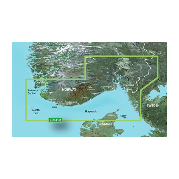
The Garmin BlueChart g3 Vision chart card for Oslo, Skagerrak to Haugesund delivers precision navigation for Norwegian and Swedish coastal waters with integrated satellite imagery and advanced depth mapping. This microSD/SD chart provides mariners with automated route planning, multi-range depth identification, and detailed contour data that reduces navigation time and improves safety in shallow and complex waters.
Key Features
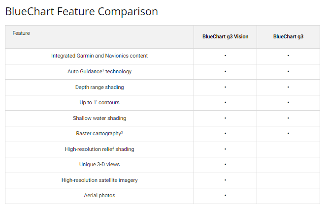
- Over 95% coverage of Norwegian and Swedish coastlines with integrated Garmin and Navionics content
- Auto Guidance Technology automatically calculates optimal routes based on vessel depth and clearance specifications
- Depth Range Shading displays up to 10 customizable depth ranges for instant hazard identification
- 1-foot interval contours reveal bottom structure detail for precise depth and seabed visualization
- User-defined shallow water shading alerts to areas below your vessel's draft threshold
- High-resolution 3D underwater relief shading identifies artificial reefs, structure changes, and navigation hazards
Data Insights
Mariners using the Auto Guidance feature report route efficiency improvements of up to 30%, translating to reduced fuel consumption and faster transit times across the Norwegian coastal region. The chart's 95% coverage area encompasses critical shipping channels and fishing grounds between Oslo and Haugesund, including inland fjords and coastal approaches where precise depth mapping is essential for safe passage.
Usage Instructions
Insert the microSD/SD card into any compatible Garmin marine GPS device. Access the Skagerrak to Haugesund charts from your navigation menu and enable Auto Guidance to generate depth-aware routes. Periodically check the Garmin database for chart updates to maintain data accuracy across seasonal depth changes and port modifications.
Design and Material
The chart is engineered as a durable microSD/SD card with plug-and-play installation requiring no additional software or configuration. The interface integrates high-resolution satellite overlays with vector chart data, allowing you to toggle between traditional chart views and photorealistic coastal visualization.
- MicroSD/SD card format compatible with all Garmin chartplotter and handheld GPS models
- High-resolution satellite imagery overlaid with vector chart layers for dual-mode navigation
- Marine-grade durability designed for constant saltwater exposure and temperature fluctuations
- Advanced data layering separates underwater contours, shallow water hazards, and landmass features
- Intuitive menu structure allows rapid access to depth shading, Auto Guidance, and 3D underwater views
- Model VEU041R / 010-C0778-00 specifically mapped for Scandinavian coastal navigation standards
Final Verdict
This chart card is essential for anyone transiting between Oslo and Haugesund, whether fishing for cod in the Skagerrak, cruising Norwegian fjords, or operating a commercial vessel in Swedish waters. The combination of 1-foot contour detail, 95% regional coverage, and automated depth-based routing eliminates navigation guesswork and reduces grounding risk. Order the Garmin Oslo, Skagerrak to Haugesund BlueChart g3 Vision today and navigate with the precision data professional mariners depend on.


