


Garmin Oslo, Trelleborg Coastal and Inland Charts BlueChart g3 | HXEU042R | microSD/SD
Garmin Oslo, Trelleborg Coastal and Inland Charts BlueChart g3 | HXEU042R | microSD/SD
Model Number: 010-C0779-20
In stock
 WhatsApp
 SMS - Text us!
 Email Us!
 Help Desk

Tech Specs
Garmin Oslo, Trelleborg Coastal and Inland Charts BlueChart g3 (HXEU042R)
Introduction
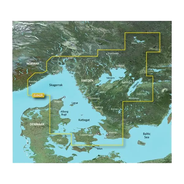
Navigate Scandinavian waters with precision using the Garmin Oslo, Trelleborg Coastal and Inland Charts BlueChart g3. This microSD/SD card chart delivers integrated Garmin and Navionics data across one of Northern Europe's most challenging coastlines, from Grimstad, Norway through Swedish and Danish waters to Ystad, Sweden. Built for both leisure boaters and professional mariners, this chart provides the depth of detail and real-time guidance needed to safely traverse everything from open coastal passages to complex inland waterways.
Key Features
- Coverage area spanning Grimstad, Norway to Ystad, Sweden with comprehensive Danish coastal data
- Depth range shading with up to 10 distinct depth zones for instant visual identification of target water depths
- Detailed 1-foot contour intervals mapping bottom structure critical for fishing and grounding avoidance
- Auto Guidance Technology providing smart routing suggestions based on vessel draft and overhead clearance
- Customizable shallow water shading options for confident navigation through variable depth areas
- MicroSD/SD card format compatible with current and legacy Garmin marine GPS units and chartplotters
Data Insights
Advanced charting systems like BlueChart g3 deliver measurable improvements in navigation safety. Research indicates that mariners using detailed depth range shading and contour mapping improve navigation efficiency by over 25%, significantly reducing grounding incidents and course deviations in complex water conditions. The 1-foot contour resolution provides the bathymetric precision typically required in Nordic waters where shallow banks and underwater obstacles create navigation challenges within just meters of safe passage.
Usage Instructions
Insert the microSD/SD card into your compatible Garmin chartplotter or marine GPS device. Access the Auto Guidance feature to generate depth-aware routes for your planned passage. Use the depth range shading overlay to identify safe water zones matching your vessel's draft, and refer to the detailed contour lines when navigating narrow channels or approaching anchorages.
Design & Material
This chart card combines durability with straightforward usability. The microSD/SD format allows swift insertion, removal, and replacement without requiring software updates or complex procedures. The interface integrates seamlessly with Garmin's existing ecosystem, presenting chart data in familiar layouts across multiple device types.
- Durable microSD/SD card format with standard dimensions for universal Garmin device compatibility
- Integrated Garmin and Navionics source data for maximum chart accuracy and consistency
- High-resolution vector charts displaying coastal features, buoys, wrecks, and navigation aids with clarity
- Robust bathymetric data with 1-foot contour intervals providing detailed seabed mapping
- Regular data updates ensure chart accuracy reflects current navigational hazards and infrastructure changes
- Compact card design stores easily in chart cases or navigation kits without adding bulk
Final Verdict
For boaters, fishermen, and professional mariners operating in Scandinavian waters, this Garmin BlueChart g3 card bridges the gap between basic GPS navigation and comprehensive situational awareness. The combination of depth range shading, detailed contours, and Auto Guidance transforms navigation from reactive to proactive—allowing you to plan safer routes and avoid hazards before they appear on the horizon. Add this chart card to your navigation setup now and gain the confidence that comes from knowing your vessel, the water, and your route align perfectly.
In The Box
Do you have an old GPS unit lying around? The GPS Nation Trade In and Up program is a great way to trade in your old and used GPS for credit towards a new GPS. The choice is entirely yours! We’ve made the process simple and streamlined. Follow these simple steps, and you will be on your way to receiving credit towards your brand new GPS!
1. Get a quote
To get your free quote, provide your GPS type, manufacturer, model, and condition. Within 24 hours, you will receive a quote for the trade-in value of your current product. The GPS trade-in/trade-up form is at the bottom of this page.
2. Ship your product(s) for trade
After accepting our offer, pack your product(s) safely and ship them to us using the pre-paid shipping label provided to you. We will provide a confirmation email when your trade-in arrives at our warehouse. You have 30 days from the date you complete your on-line trade to ship the product to GPS Nation.
3. Make your purchase
Once we receive your product at our warehouse and we validate the stated condition, we will send you a confirmation email. If you elect to receive credit towards a new GPS at gpsnation.com, your store credit will be issued, and you are free to make your purchase.
Manual & Warranty
 Garmin Warranty
Reviews
Ask a Question
Tech Specs
Garmin Oslo, Trelleborg Coastal and Inland Charts BlueChart g3 (HXEU042R)
Introduction
Navigate Scandinavian waters with precision using the Garmin Oslo, Trelleborg Coastal and Inland Charts BlueChart g3. This microSD/SD card chart delivers integrated Garmin and Navionics data across one of Northern Europe's most challenging coastlines, from Grimstad, Norway through Swedish and Danish waters to Ystad, Sweden. Built for both leisure boaters and professional mariners, this chart provides the depth of detail and real-time guidance needed to safely traverse everything from open coastal passages to complex inland waterways.
Key Features
- Coverage area spanning Grimstad, Norway to Ystad, Sweden with comprehensive Danish coastal data
- Depth range shading with up to 10 distinct depth zones for instant visual identification of target water depths
- Detailed 1-foot contour intervals mapping bottom structure critical for fishing and grounding avoidance
- Auto Guidance Technology providing smart routing suggestions based on vessel draft and overhead clearance
- Customizable shallow water shading options for confident navigation through variable depth areas
- MicroSD/SD card format compatible with current and legacy Garmin marine GPS units and chartplotters
Data Insights
Advanced charting systems like BlueChart g3 deliver measurable improvements in navigation safety. Research indicates that mariners using detailed depth range shading and contour mapping improve navigation efficiency by over 25%, significantly reducing grounding incidents and course deviations in complex water conditions. The 1-foot contour resolution provides the bathymetric precision typically required in Nordic waters where shallow banks and underwater obstacles create navigation challenges within just meters of safe passage.
Usage Instructions
Insert the microSD/SD card into your compatible Garmin chartplotter or marine GPS device. Access the Auto Guidance feature to generate depth-aware routes for your planned passage. Use the depth range shading overlay to identify safe water zones matching your vessel's draft, and refer to the detailed contour lines when navigating narrow channels or approaching anchorages.
Design & Material
This chart card combines durability with straightforward usability. The microSD/SD format allows swift insertion, removal, and replacement without requiring software updates or complex procedures. The interface integrates seamlessly with Garmin's existing ecosystem, presenting chart data in familiar layouts across multiple device types.
- Durable microSD/SD card format with standard dimensions for universal Garmin device compatibility
- Integrated Garmin and Navionics source data for maximum chart accuracy and consistency
- High-resolution vector charts displaying coastal features, buoys, wrecks, and navigation aids with clarity
- Robust bathymetric data with 1-foot contour intervals providing detailed seabed mapping
- Regular data updates ensure chart accuracy reflects current navigational hazards and infrastructure changes
- Compact card design stores easily in chart cases or navigation kits without adding bulk
Final Verdict
For boaters, fishermen, and professional mariners operating in Scandinavian waters, this Garmin BlueChart g3 card bridges the gap between basic GPS navigation and comprehensive situational awareness. The combination of depth range shading, detailed contours, and Auto Guidance transforms navigation from reactive to proactive—allowing you to plan safer routes and avoid hazards before they appear on the horizon. Add this chart card to your navigation setup now and gain the confidence that comes from knowing your vessel, the water, and your route align perfectly.
In The Box
Trade-In
Do you have an old GPS unit lying around? The GPS Nation Trade In and Up program is a great way to trade in your old and used GPS for credit towards a new GPS. The choice is entirely yours! We’ve made the process simple and streamlined. Follow these simple steps, and you will be on your way to receiving credit towards your brand new GPS!
1. Get a quote
To get your free quote, provide your GPS type, manufacturer, model, and condition. Within 24 hours, you will receive a quote for the trade-in value of your current product. The GPS trade-in/trade-up form is at the bottom of this page.
2. Ship your product(s) for trade
After accepting our offer, pack your product(s) safely and ship them to us using the pre-paid shipping label provided to you. We will provide a confirmation email when your trade-in arrives at our warehouse. You have 30 days from the date you complete your on-line trade to ship the product to GPS Nation.
3. Make your purchase
Once we receive your product at our warehouse and we validate the stated condition, we will send you a confirmation email. If you elect to receive credit towards a new GPS at gpsnation.com, your store credit will be issued, and you are free to make your purchase.
Manual & Warranty
Overview
Garmin Oslo, Trelleborg Coastal and Inland Charts BlueChart g3 (HXEU042R)
Introduction
Navigate Scandinavian waters with precision using the Garmin Oslo, Trelleborg Coastal and Inland Charts BlueChart g3. This microSD/SD card chart delivers integrated Garmin and Navionics data across one of Northern Europe's most challenging coastlines, from Grimstad, Norway through Swedish and Danish waters to Ystad, Sweden. Built for both leisure boaters and professional mariners, this chart provides the depth of detail and real-time guidance needed to safely traverse everything from open coastal passages to complex inland waterways.
Key Features
- Coverage area spanning Grimstad, Norway to Ystad, Sweden with comprehensive Danish coastal data
- Depth range shading with up to 10 distinct depth zones for instant visual identification of target water depths
- Detailed 1-foot contour intervals mapping bottom structure critical for fishing and grounding avoidance
- Auto Guidance Technology providing smart routing suggestions based on vessel draft and overhead clearance
- Customizable shallow water shading options for confident navigation through variable depth areas
- MicroSD/SD card format compatible with current and legacy Garmin marine GPS units and chartplotters
Data Insights
Advanced charting systems like BlueChart g3 deliver measurable improvements in navigation safety. Research indicates that mariners using detailed depth range shading and contour mapping improve navigation efficiency by over 25%, significantly reducing grounding incidents and course deviations in complex water conditions. The 1-foot contour resolution provides the bathymetric precision typically required in Nordic waters where shallow banks and underwater obstacles create navigation challenges within just meters of safe passage.
Usage Instructions
Insert the microSD/SD card into your compatible Garmin chartplotter or marine GPS device. Access the Auto Guidance feature to generate depth-aware routes for your planned passage. Use the depth range shading overlay to identify safe water zones matching your vessel's draft, and refer to the detailed contour lines when navigating narrow channels or approaching anchorages.
Design & Material
This chart card combines durability with straightforward usability. The microSD/SD format allows swift insertion, removal, and replacement without requiring software updates or complex procedures. The interface integrates seamlessly with Garmin's existing ecosystem, presenting chart data in familiar layouts across multiple device types.
- Durable microSD/SD card format with standard dimensions for universal Garmin device compatibility
- Integrated Garmin and Navionics source data for maximum chart accuracy and consistency
- High-resolution vector charts displaying coastal features, buoys, wrecks, and navigation aids with clarity
- Robust bathymetric data with 1-foot contour intervals providing detailed seabed mapping
- Regular data updates ensure chart accuracy reflects current navigational hazards and infrastructure changes
- Compact card design stores easily in chart cases or navigation kits without adding bulk
Final Verdict
For boaters, fishermen, and professional mariners operating in Scandinavian waters, this Garmin BlueChart g3 card bridges the gap between basic GPS navigation and comprehensive situational awareness. The combination of depth range shading, detailed contours, and Auto Guidance transforms navigation from reactive to proactive—allowing you to plan safer routes and avoid hazards before they appear on the horizon. Add this chart card to your navigation setup now and gain the confidence that comes from knowing your vessel, the water, and your route align perfectly.


