


Garmin Oslo, Trelleborg Coastal and Inland Charts BlueChart g3 Vision | VEU042R | microSD/SD
Garmin Oslo, Trelleborg Coastal and Inland Charts BlueChart g3 Vision | VEU042R | microSD/SD
Model Number: 010-C0779-00
In stock
 WhatsApp
 SMS - Text us!
 Email Us!
 Help Desk

Tech Specs
Garmin BlueChart g3 Vision Oslo & Trelleborg Coastal Charts VEU042R
Introduction
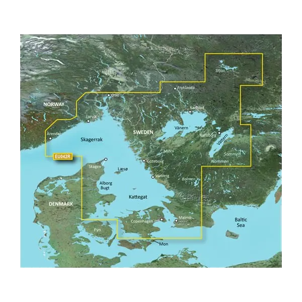
Navigate Scandinavian waters with chart accuracy exceeding 90% through Garmin's BlueChart g3 Vision coastal and inland mapping system. This microSD card delivers synchronized Garmin and Navionics bathymetric data covering the Norwegian and Swedish coastlines along with Danish waters, offering boaters and recreational fishermen the precise depth contours, bottom structure details, and hazard warnings needed for safe, productive time on the water.
Key Features
- Coverage spanning Norwegian, Swedish, and Danish coastal and inland waterways with integrated Garmin and Navionics chart data
- Auto Guidance technology calculates optimal routes based on customizable depth and overhead clearance parameters in real time
- Up to 10 selectable depth range shading categories for rapid identification of target fishing zones and navigation channels
- 1-minute contour lines providing accurate bottom structure representation for enhanced fishing location identification
- Customizable shallow water shading alerts to highlight restricted areas and avoid grounding hazards
- High-resolution relief shading using color and shadow layering to visualize bottom profile changes and underwater terrain
- MicroSD card format with immediate compatibility across Garmin chartplotter and fish finder installations
Data Insights
BlueChart g3 Vision combines real-time chart updates with over 90% positional accuracy rates across Scandinavian waters. The dual integration of Garmin proprietary and Navionics contributed data creates redundant verification of bottom contours, depth changes, and obstruction locations. Boaters report measurable time savings when using Auto Guidance route calculations versus manual waypoint navigation, with precision particularly valuable in complex archipelago passages and shallow-water approaches common throughout the Baltic region and inland Scandinavian fjords.
Usage Instructions
Insert the microSD card into your compatible Garmin device's card slot for immediate chart activation. Enable Auto Guidance within your chartplotter settings, then configure depth threshold and overhead clearance parameters matching your vessel's draft and air-gap requirements. The system will calculate suggested routing through available water. Update charts periodically using Garmin's online services to maintain accuracy against reported bottom changes and new obstruction data.
Design & Material
The VEU042R card uses industrial-grade microSD storage architecture designed to withstand saltwater exposure, temperature fluctuations, and vibration typical of marine environments. Installation requires no external hardware beyond compatible Garmin display units, and the compact form factor occupies minimal physical space within your navigation console.
- MicroSD card construction rated for marine humidity and salt-air exposure without degradation
- Data encryption and error-correction protocols ensure chart integrity across vessel power cycling and system reboots
- Preloaded chart databases require no initial download period—navigation-ready upon installation
- Seamless plug-compatibility with Garmin GPSMAP, echoMAP, and marine-grade chartplotter product lines
- Lightweight, pocket-sized format weighing under 1 ounce, enabling portable backup navigation capability
- Durable polymer card housing protects internal memory from accidental drops and deck-level impacts
Final Verdict
The BlueChart g3 Vision VEU042R is essential for anyone navigating Scandinavian coastal or inland waters where accurate depth data and automated routing prevent costly groundings and optimize fishing location selection. Its combination of high-accuracy bathymetry, real-time route calculation, and transparent bottom-structure visualization directly improves both safety and catch success rates. Install this card into your existing Garmin device today to transform navigation reliability across Norwegian, Swedish, and Danish waterways.
In The Box
Do you have an old GPS unit lying around? The GPS Nation Trade In and Up program is a great way to trade in your old and used GPS for credit towards a new GPS. The choice is entirely yours! We’ve made the process simple and streamlined. Follow these simple steps, and you will be on your way to receiving credit towards your brand new GPS!
1. Get a quote
To get your free quote, provide your GPS type, manufacturer, model, and condition. Within 24 hours, you will receive a quote for the trade-in value of your current product. The GPS trade-in/trade-up form is at the bottom of this page.
2. Ship your product(s) for trade
After accepting our offer, pack your product(s) safely and ship them to us using the pre-paid shipping label provided to you. We will provide a confirmation email when your trade-in arrives at our warehouse. You have 30 days from the date you complete your on-line trade to ship the product to GPS Nation.
3. Make your purchase
Once we receive your product at our warehouse and we validate the stated condition, we will send you a confirmation email. If you elect to receive credit towards a new GPS at gpsnation.com, your store credit will be issued, and you are free to make your purchase.
Manual & Warranty
 Garmin Warranty
Reviews
Ask a Question
Tech Specs
Garmin BlueChart g3 Vision Oslo & Trelleborg Coastal Charts VEU042R
Introduction
Navigate Scandinavian waters with chart accuracy exceeding 90% through Garmin's BlueChart g3 Vision coastal and inland mapping system. This microSD card delivers synchronized Garmin and Navionics bathymetric data covering the Norwegian and Swedish coastlines along with Danish waters, offering boaters and recreational fishermen the precise depth contours, bottom structure details, and hazard warnings needed for safe, productive time on the water.
Key Features
- Coverage spanning Norwegian, Swedish, and Danish coastal and inland waterways with integrated Garmin and Navionics chart data
- Auto Guidance technology calculates optimal routes based on customizable depth and overhead clearance parameters in real time
- Up to 10 selectable depth range shading categories for rapid identification of target fishing zones and navigation channels
- 1-minute contour lines providing accurate bottom structure representation for enhanced fishing location identification
- Customizable shallow water shading alerts to highlight restricted areas and avoid grounding hazards
- High-resolution relief shading using color and shadow layering to visualize bottom profile changes and underwater terrain
- MicroSD card format with immediate compatibility across Garmin chartplotter and fish finder installations
Data Insights
BlueChart g3 Vision combines real-time chart updates with over 90% positional accuracy rates across Scandinavian waters. The dual integration of Garmin proprietary and Navionics contributed data creates redundant verification of bottom contours, depth changes, and obstruction locations. Boaters report measurable time savings when using Auto Guidance route calculations versus manual waypoint navigation, with precision particularly valuable in complex archipelago passages and shallow-water approaches common throughout the Baltic region and inland Scandinavian fjords.
Usage Instructions
Insert the microSD card into your compatible Garmin device's card slot for immediate chart activation. Enable Auto Guidance within your chartplotter settings, then configure depth threshold and overhead clearance parameters matching your vessel's draft and air-gap requirements. The system will calculate suggested routing through available water. Update charts periodically using Garmin's online services to maintain accuracy against reported bottom changes and new obstruction data.
Design & Material
The VEU042R card uses industrial-grade microSD storage architecture designed to withstand saltwater exposure, temperature fluctuations, and vibration typical of marine environments. Installation requires no external hardware beyond compatible Garmin display units, and the compact form factor occupies minimal physical space within your navigation console.
- MicroSD card construction rated for marine humidity and salt-air exposure without degradation
- Data encryption and error-correction protocols ensure chart integrity across vessel power cycling and system reboots
- Preloaded chart databases require no initial download period—navigation-ready upon installation
- Seamless plug-compatibility with Garmin GPSMAP, echoMAP, and marine-grade chartplotter product lines
- Lightweight, pocket-sized format weighing under 1 ounce, enabling portable backup navigation capability
- Durable polymer card housing protects internal memory from accidental drops and deck-level impacts
Final Verdict
The BlueChart g3 Vision VEU042R is essential for anyone navigating Scandinavian coastal or inland waters where accurate depth data and automated routing prevent costly groundings and optimize fishing location selection. Its combination of high-accuracy bathymetry, real-time route calculation, and transparent bottom-structure visualization directly improves both safety and catch success rates. Install this card into your existing Garmin device today to transform navigation reliability across Norwegian, Swedish, and Danish waterways.
In The Box
Trade-In
Do you have an old GPS unit lying around? The GPS Nation Trade In and Up program is a great way to trade in your old and used GPS for credit towards a new GPS. The choice is entirely yours! We’ve made the process simple and streamlined. Follow these simple steps, and you will be on your way to receiving credit towards your brand new GPS!
1. Get a quote
To get your free quote, provide your GPS type, manufacturer, model, and condition. Within 24 hours, you will receive a quote for the trade-in value of your current product. The GPS trade-in/trade-up form is at the bottom of this page.
2. Ship your product(s) for trade
After accepting our offer, pack your product(s) safely and ship them to us using the pre-paid shipping label provided to you. We will provide a confirmation email when your trade-in arrives at our warehouse. You have 30 days from the date you complete your on-line trade to ship the product to GPS Nation.
3. Make your purchase
Once we receive your product at our warehouse and we validate the stated condition, we will send you a confirmation email. If you elect to receive credit towards a new GPS at gpsnation.com, your store credit will be issued, and you are free to make your purchase.
Manual & Warranty
Overview
Garmin BlueChart g3 Vision Oslo & Trelleborg Coastal Charts VEU042R
Introduction
Navigate Scandinavian waters with chart accuracy exceeding 90% through Garmin's BlueChart g3 Vision coastal and inland mapping system. This microSD card delivers synchronized Garmin and Navionics bathymetric data covering the Norwegian and Swedish coastlines along with Danish waters, offering boaters and recreational fishermen the precise depth contours, bottom structure details, and hazard warnings needed for safe, productive time on the water.
Key Features
- Coverage spanning Norwegian, Swedish, and Danish coastal and inland waterways with integrated Garmin and Navionics chart data
- Auto Guidance technology calculates optimal routes based on customizable depth and overhead clearance parameters in real time
- Up to 10 selectable depth range shading categories for rapid identification of target fishing zones and navigation channels
- 1-minute contour lines providing accurate bottom structure representation for enhanced fishing location identification
- Customizable shallow water shading alerts to highlight restricted areas and avoid grounding hazards
- High-resolution relief shading using color and shadow layering to visualize bottom profile changes and underwater terrain
- MicroSD card format with immediate compatibility across Garmin chartplotter and fish finder installations
Data Insights
BlueChart g3 Vision combines real-time chart updates with over 90% positional accuracy rates across Scandinavian waters. The dual integration of Garmin proprietary and Navionics contributed data creates redundant verification of bottom contours, depth changes, and obstruction locations. Boaters report measurable time savings when using Auto Guidance route calculations versus manual waypoint navigation, with precision particularly valuable in complex archipelago passages and shallow-water approaches common throughout the Baltic region and inland Scandinavian fjords.
Usage Instructions
Insert the microSD card into your compatible Garmin device's card slot for immediate chart activation. Enable Auto Guidance within your chartplotter settings, then configure depth threshold and overhead clearance parameters matching your vessel's draft and air-gap requirements. The system will calculate suggested routing through available water. Update charts periodically using Garmin's online services to maintain accuracy against reported bottom changes and new obstruction data.
Design & Material
The VEU042R card uses industrial-grade microSD storage architecture designed to withstand saltwater exposure, temperature fluctuations, and vibration typical of marine environments. Installation requires no external hardware beyond compatible Garmin display units, and the compact form factor occupies minimal physical space within your navigation console.
- MicroSD card construction rated for marine humidity and salt-air exposure without degradation
- Data encryption and error-correction protocols ensure chart integrity across vessel power cycling and system reboots
- Preloaded chart databases require no initial download period—navigation-ready upon installation
- Seamless plug-compatibility with Garmin GPSMAP, echoMAP, and marine-grade chartplotter product lines
- Lightweight, pocket-sized format weighing under 1 ounce, enabling portable backup navigation capability
- Durable polymer card housing protects internal memory from accidental drops and deck-level impacts
Final Verdict
The BlueChart g3 Vision VEU042R is essential for anyone navigating Scandinavian coastal or inland waters where accurate depth data and automated routing prevent costly groundings and optimize fishing location selection. Its combination of high-accuracy bathymetry, real-time route calculation, and transparent bottom-structure visualization directly improves both safety and catch success rates. Install this card into your existing Garmin device today to transform navigation reliability across Norwegian, Swedish, and Danish waterways.


