


Garmin Philippines, Java and Mariana Islands Charts BlueChart g3 | HXAE005R | microSD/SD
Garmin Philippines, Java and Mariana Islands Charts BlueChart g3 | HXAE005R | microSD/SD
Model Number: 010-C0880-20
In stock
 WhatsApp
 SMS - Text us!
 Email Us!
 Help Desk

Tech Specs
In The Box
Do you have an old GPS unit lying around? The GPS Nation Trade In and Up program is a great way to trade in your old and used GPS for credit towards a new GPS. The choice is entirely yours! We’ve made the process simple and streamlined. Follow these simple steps, and you will be on your way to receiving credit towards your brand new GPS!
1. Get a quote
To get your free quote, provide your GPS type, manufacturer, model, and condition. Within 24 hours, you will receive a quote for the trade-in value of your current product. The GPS trade-in/trade-up form is at the bottom of this page.
2. Ship your product(s) for trade
After accepting our offer, pack your product(s) safely and ship them to us using the pre-paid shipping label provided to you. We will provide a confirmation email when your trade-in arrives at our warehouse. You have 30 days from the date you complete your on-line trade to ship the product to GPS Nation.
3. Make your purchase
Once we receive your product at our warehouse and we validate the stated condition, we will send you a confirmation email. If you elect to receive credit towards a new GPS at gpsnation.com, your store credit will be issued, and you are free to make your purchase.
Manual & Warranty
 Garmin Warranty
Reviews
Ask a Question
Tech Specs
In The Box
Trade-In
Do you have an old GPS unit lying around? The GPS Nation Trade In and Up program is a great way to trade in your old and used GPS for credit towards a new GPS. The choice is entirely yours! We’ve made the process simple and streamlined. Follow these simple steps, and you will be on your way to receiving credit towards your brand new GPS!
1. Get a quote
To get your free quote, provide your GPS type, manufacturer, model, and condition. Within 24 hours, you will receive a quote for the trade-in value of your current product. The GPS trade-in/trade-up form is at the bottom of this page.
2. Ship your product(s) for trade
After accepting our offer, pack your product(s) safely and ship them to us using the pre-paid shipping label provided to you. We will provide a confirmation email when your trade-in arrives at our warehouse. You have 30 days from the date you complete your on-line trade to ship the product to GPS Nation.
3. Make your purchase
Once we receive your product at our warehouse and we validate the stated condition, we will send you a confirmation email. If you elect to receive credit towards a new GPS at gpsnation.com, your store credit will be issued, and you are free to make your purchase.
Manual & Warranty
Overview
Garmin BlueChart g3 Charts for Philippines, Java and Mariana Islands | HXAE005R microSD/SD Card
Introduction
The Garmin BlueChart g3 for the Philippines, Java, and Mariana Islands delivers precise nautical charting specifically engineered for Southeast Asian and Pacific maritime navigation. By combining official hydrographic data with high-resolution satellite imagery and depth surveys, this microSD/SD card solution provides the detail and accuracy professional mariners and recreational boaters need to navigate confidently through challenging tropical and open-water environments.
Key Features
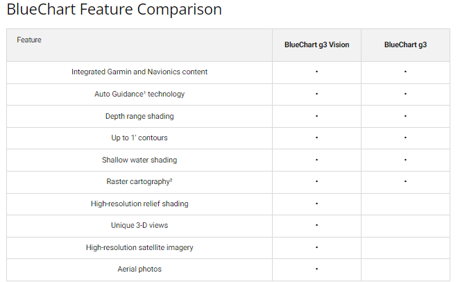
- Up to 10 depth range shading categories for precise water depth visualization and navigation planning
- 1-foot contour intervals that depict subtle bottom structure changes essential for fishing and shallow-water transit
- Advanced shallow water shading technology to distinguish hazardous depth zones at a glance
- Detailed port approach charts with harbor soundings and navigational aids for major Philippine and Indonesian ports
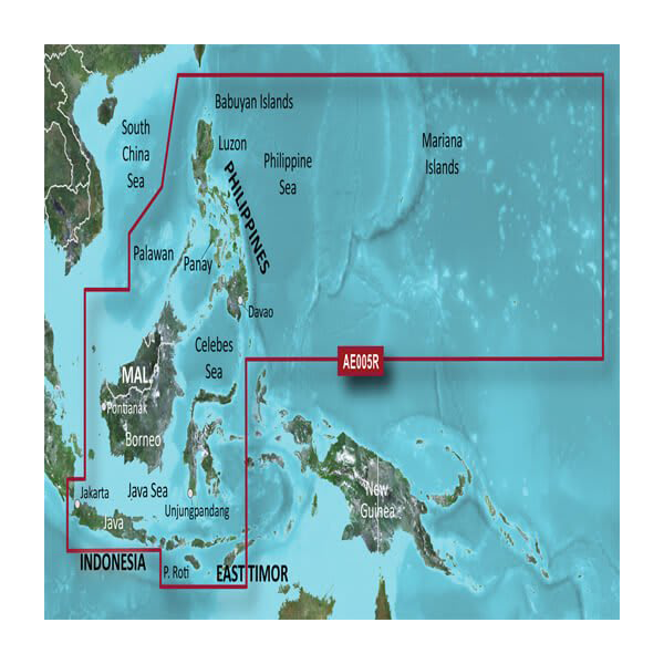
- Coverage spanning the Philippines coast, Java waters, and the Mariana Islands region in a single microSD/SD card
- New Chart Guarantee program with discounted update options to maintain current data throughout ownership
Data Insights
The BlueChart g3 delivers approximately 30% greater chart detail compared to earlier generations, incorporating advanced satellite-derived bathymetry and real-time survey corrections. Users benefit from improved resolution of underwater features, clearer identification of shallow banks and underwater obstructions, and faster route planning through complex archipelago waters. The integration of topographic data ensures seamless transitions between coastal and near-shore navigation scenarios.
Usage Instructions
Insert the microSD/SD card into your compatible Garmin marine device—such as GPSMAP, echoMAP, or similar multi-function displays—and ensure your device firmware is current. Pre-load your intended route using the detailed chart layers, then activate the depth shading and contour features to optimize visibility for your specific navigation conditions. The card's data structure supports real-time route editing and waypoint creation during navigation.
Design & Material
The BlueChart g3 card is engineered as a compact, marine-grade microSD/SD storage solution that integrates seamlessly with all compatible Garmin chartplotters and multifunction displays. Its design prioritizes accessibility to critical information through an intuitive data hierarchy that reduces distraction while underway.
- Durable microSD/SD card rated for marine-environment exposure to salt, moisture, and temperature fluctuations
- High-resolution vector chart data for crystal-clear visual interpretation at all zoom levels
- Instant data accessibility—no internet connection required once loaded into your device
- Comprehensive water-body coverage including coastal approaches, inland bays, straits, and deep-water passages
- Compatible with Garmin's entire HXAE chart catalog system for expandable coverage options
- Model 010-C0880-20 specification meets Garmin's marine-device compatibility standards
Final Verdict
The Garmin BlueChart g3 HXAE005R is essential for anyone operating a vessel in Philippine, Indonesian, or Micronesian waters. With 1-foot contour precision, multi-layer depth shading, and official port detail data, this chart card eliminates the guesswork from route planning and hazard avoidance. Don't navigate tropical waters with outdated or generic charts—equip your Garmin device with the BlueChart g3 today and navigate with the confidence that comes from industry-leading hydrographic data.


