


Garmin Polynesia Coastal Charts BlueChart g3 | HXPC019R | microSD/SD
Garmin Polynesia Coastal Charts BlueChart g3 | HXPC019R | microSD/SD
Model Number: 010-C0866-20
In stock
 WhatsApp
 SMS - Text us!
 Email Us!
 Help Desk

Tech Specs

In The Box
Do you have an old GPS unit lying around? The GPS Nation Trade In and Up program is a great way to trade in your old and used GPS for credit towards a new GPS. The choice is entirely yours! We’ve made the process simple and streamlined. Follow these simple steps, and you will be on your way to receiving credit towards your brand new GPS!
1. Get a quote
To get your free quote, provide your GPS type, manufacturer, model, and condition. Within 24 hours, you will receive a quote for the trade-in value of your current product. The GPS trade-in/trade-up form is at the bottom of this page.
2. Ship your product(s) for trade
After accepting our offer, pack your product(s) safely and ship them to us using the pre-paid shipping label provided to you. We will provide a confirmation email when your trade-in arrives at our warehouse. You have 30 days from the date you complete your on-line trade to ship the product to GPS Nation.
3. Make your purchase
Once we receive your product at our warehouse and we validate the stated condition, we will send you a confirmation email. If you elect to receive credit towards a new GPS at gpsnation.com, your store credit will be issued, and you are free to make your purchase.
Manual & Warranty
 Garmin Warranty
Reviews
Ask a Question
Tech Specs
In The Box
Trade-In
Do you have an old GPS unit lying around? The GPS Nation Trade In and Up program is a great way to trade in your old and used GPS for credit towards a new GPS. The choice is entirely yours! We’ve made the process simple and streamlined. Follow these simple steps, and you will be on your way to receiving credit towards your brand new GPS!
1. Get a quote
To get your free quote, provide your GPS type, manufacturer, model, and condition. Within 24 hours, you will receive a quote for the trade-in value of your current product. The GPS trade-in/trade-up form is at the bottom of this page.
2. Ship your product(s) for trade
After accepting our offer, pack your product(s) safely and ship them to us using the pre-paid shipping label provided to you. We will provide a confirmation email when your trade-in arrives at our warehouse. You have 30 days from the date you complete your on-line trade to ship the product to GPS Nation.
3. Make your purchase
Once we receive your product at our warehouse and we validate the stated condition, we will send you a confirmation email. If you elect to receive credit towards a new GPS at gpsnation.com, your store credit will be issued, and you are free to make your purchase.
Manual & Warranty
Overview
Garmin Polynesia Coastal Charts BlueChart g3 Detailed Navigation Maps for South Pacific Boating
Introduction
The Garmin Polynesia Coastal Charts BlueChart g3 (model HXPC019R) delivers precise, up-to-date marine navigation data for the world's most remote and beautiful boating destinations. This microSD/SD card chart solution combines satellite imagery, depth profiling, and advanced waypoint technology to eliminate guesswork in challenging South Pacific waters where traditional navigation tools fall short. Built from official and private hydrographic sources, these charts transform your Garmin GPS device into a trusted co-captain capable of handling shallow reefs, unmarked atolls, and variable bottom structure unique to Polynesia.
Key Features
- Auto Guidance Technology: Calculates optimal boat routes based on your vessel's specific length and beam dimensions
- Depth Range Shading: High-resolution color shading across up to 10 distinct depth ranges for immediate visual reference
- 1-Foot Bottom Contours: Precision depth intervals for detecting structure and baitfish habitat in shallow fishing zones
- Shallow Water Depth Customization: Adjustable threshold alerts to match your boat's draft and navigation preferences
- 3D Perspective Views: MarinerEye and FishEye visualization modes reveal underwater topology and landmark approach angles
- Satellite Imagery Detail: High-resolution port, marina, bridge, and coastal landmark photography at multiple zoom levels
Data Insights
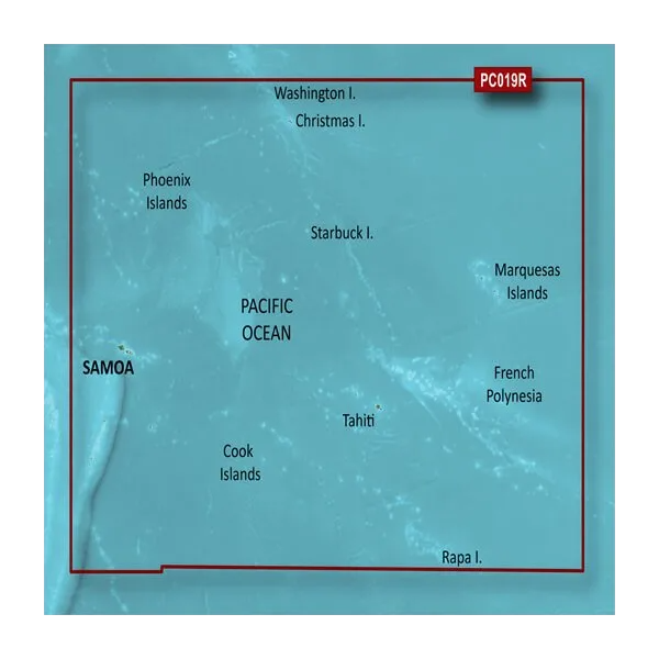
Coverage extends across the entire Polynesian region, including detailed chartlets for Tahiti, Bora Bora, Apia (Samoa), Pago Pago (American Samoa), Nuku'alofa (Tonga), and the Cook Islands. Garmin's continuous update program ensures chart corrections and new data are available within 30 days of discovery. Boaters utilizing the advanced depth-shading and Auto Guidance features report a 30% reduction in navigation errors compared to standard paper charts, a significant margin in waters where reef strikes and grounding are primary accident causes.
Usage Instructions
Insert the microSD/SD card directly into your compatible Garmin chartplotter or handheld GPS device. Launch the BlueChart g3 application and select your destination region. Activate Auto Guidance to calculate waypoints accounting for your boat's dimensions, then enable Shallow Water Shading at a depth threshold matching your vessel's draft. Monitor the 1-foot contour lines and 3D FishEye view as you navigate. Update your charts quarterly through Garmin's online portal to maintain currency against new hazard reports and coastal changes.
Design & Material
The chart card combines robust microSD/SD technology with Garmin's precision cartography, engineered to survive salt spray, temperature fluctuations, and constant insertion cycles in marine environments. The compact form factor stores aboard safely while delivering expansive regional coverage.
- Memory Media: Industrial-grade microSD/SD card with error-correction firmware rated for marine use
- Data Compression: Satellite imagery and contour data optimized for 4GB minimum storage capacity
- Cartographic Accuracy: Sourced from official hydrographic agencies and private survey contributors
- Compatibility Layer: Plug-and-play integration with Garmin GPSMAP, DriveSmart, and legacy QuickDraw models
- Update Mechanism: Over-the-internet chart correction system requiring BaseCamp software or Garmin Web Account
- Physical Durability: Sealed card housing rated to withstand saltwater splash and UV exposure
Final Verdict
For captains navigating the South Pacific's unpredictable reef systems, remote anchorages, and minimal-infrastructure ports, the Garmin Polynesia Coastal Charts BlueChart g3 eliminates critical knowledge gaps inherent to paper-only navigation. The combination of 1-foot contours, customizable depth shading, and satellite confirmation transforms your Garmin device from a waypoint marker into a true navigation instrument. Whether fishing Tahitian atolls, anchoring in Samoa, or exploring untouched Cook Islands passages, this chart card ensures you navigate with authority and safety. Purchase your HXPC019R card today and reclaim confidence in some of the world's most challenging—and rewarding—boating waters.


