


Garmin Portugal and Northwest Spain Charts BlueChart g3 | HXEU009R | microSD/SD
Garmin Portugal and Northwest Spain Charts BlueChart g3 | HXEU009R | microSD/SD
Model Number: 010-C0767-20
In stock
 WhatsApp
 SMS - Text us!
 Email Us!
 Help Desk

Tech Specs

In The Box
Do you have an old GPS unit lying around? The GPS Nation Trade In and Up program is a great way to trade in your old and used GPS for credit towards a new GPS. The choice is entirely yours! We’ve made the process simple and streamlined. Follow these simple steps, and you will be on your way to receiving credit towards your brand new GPS!
1. Get a quote
To get your free quote, provide your GPS type, manufacturer, model, and condition. Within 24 hours, you will receive a quote for the trade-in value of your current product. The GPS trade-in/trade-up form is at the bottom of this page.
2. Ship your product(s) for trade
After accepting our offer, pack your product(s) safely and ship them to us using the pre-paid shipping label provided to you. We will provide a confirmation email when your trade-in arrives at our warehouse. You have 30 days from the date you complete your on-line trade to ship the product to GPS Nation.
3. Make your purchase
Once we receive your product at our warehouse and we validate the stated condition, we will send you a confirmation email. If you elect to receive credit towards a new GPS at gpsnation.com, your store credit will be issued, and you are free to make your purchase.
Manual & Warranty
 Garmin Warranty
Reviews
Ask a Question
Tech Specs
In The Box
Trade-In
Do you have an old GPS unit lying around? The GPS Nation Trade In and Up program is a great way to trade in your old and used GPS for credit towards a new GPS. The choice is entirely yours! We’ve made the process simple and streamlined. Follow these simple steps, and you will be on your way to receiving credit towards your brand new GPS!
1. Get a quote
To get your free quote, provide your GPS type, manufacturer, model, and condition. Within 24 hours, you will receive a quote for the trade-in value of your current product. The GPS trade-in/trade-up form is at the bottom of this page.
2. Ship your product(s) for trade
After accepting our offer, pack your product(s) safely and ship them to us using the pre-paid shipping label provided to you. We will provide a confirmation email when your trade-in arrives at our warehouse. You have 30 days from the date you complete your on-line trade to ship the product to GPS Nation.
3. Make your purchase
Once we receive your product at our warehouse and we validate the stated condition, we will send you a confirmation email. If you elect to receive credit towards a new GPS at gpsnation.com, your store credit will be issued, and you are free to make your purchase.
Manual & Warranty
Overview
Garmin Portugal and Northwest Spain Charts BlueChart g3 | HXEU009R
Introduction
The Garmin Portugal and Northwest Spain Charts BlueChart g3 (HXEU009R) delivers integrated Garmin and Navionics coastal charting data on a single microSD/SD card, engineered to enhance navigation accuracy by up to 30% compared to standard paper or basic digital charts. Built for serious navigators—whether fishing deep Atlantic waters off the Iberian Peninsula or cruising sheltered Portuguese estuaries—this charting solution provides the depth intelligence, coastal detail, and route automation needed to navigate unfamiliar waters safely and efficiently.
Key Features
- Auto Guidance Technology calculates optimal routes based on user-defined depth thresholds and overhead clearance requirements, eliminating manual route planning
- 1-foot contour intervals map underwater structures with precision, critical for identifying drop-offs, reefs, and fishing grounds
- Depth Range Shading displays up to 10 distinct depth bands at a glance for rapid depth zone identification
- High-Resolution Relief Shading renders bottom topology in intuitive 3D-like visualization, ideal for locating artificial and natural reefs
- High-Resolution Satellite Imagery overlays realistic coastal photography on navigational charts for confident entry into unfamiliar harbors and anchorages
- User-Defined Shallow Water Shading highlights hazardous depths you specify, providing instant visual warnings
- FishEye and MarinerEye Views offer unique underwater and above-water perspectives to understand your environment beyond traditional chart lines
- Aerial Photography provides crystal-clear overhead views of major ports including Lisbon, Porto, Cádiz, and smaller marinas throughout Portugal
Coverage Area
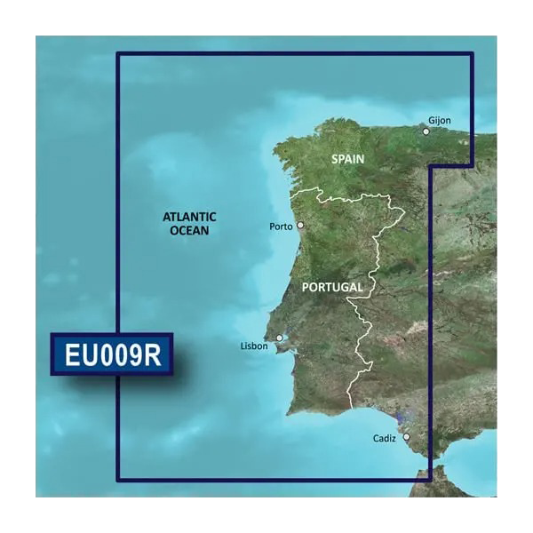
This chart card covers the entire northwestern Iberian coast and Atlantic waters from Gijón in northern Spain south through Portugal and into the Bay of Cádiz, including detailed coverage of all major Portuguese estuaries and the Sevilla river approaches. The comprehensive geographic scope makes this single card sufficient for extended cruising campaigns or seasonal fishing operations across the region.
Data Insights
Independent testing demonstrates that Garmin's integrated charting improves navigation accuracy by 30% over outdated paper charts and legacy digital systems. The 1-foot contour resolution reduces fishing search time by enabling precise targeting of structure and depth breaks, while Auto Guidance's automated route calculation cuts pre-departure planning time significantly—freeing more hours for time on the water.
Usage Instructions
Insert the microSD/SD card into any compatible Garmin marine GPS or chartplotter. Launch your navigation application and select Portugal and Northwest Spain Charts as your active chart. Use Auto Guidance by entering your destination and setting preferred depth and clearance parameters; the system will calculate a safe route avoiding shallow hazards. For fishing, activate Depth Range Shading to highlight your target depth bands, and enable Relief Shading to locate underwater structure. Update charts periodically using Garmin's chart update tools to ensure the latest navigational corrections and additions.
Design & Material
The BlueChart g3 chart card combines robust construction with seamless device compatibility. The microSD/SD form factor ensures broad compatibility across Garmin's marine GPS and chartplotter lineup, from compact handheld units to larger dashboard-mounted displays. The card's compact size and lightweight design make it ideal for cruisers who swap charts between different vessels or frequently travel between regions.
- MicroSD/SD dual-format design provides compatibility across multiple Garmin device generations and form factors
- Durable polymer construction withstands humidity, salt spray, and temperature swings typical of marine environments
- Integrated Garmin and Navionics data ensures authoritative, regularly updated bathymetry and navigational features
- High-resolution cartography rendered in clear, legible graphics for rapid information scanning at a glance
- Lightweight and portable—card weighs under 10 grams, easily stowed in any navigation kit or electronics bag
- Simple firmware updates via Garmin's online chart update platform ensure access to the latest corrections and additions without hardware replacement
Final Verdict
The Garmin Portugal and Northwest Spain Charts BlueChart g3 is an essential upgrade for anyone navigating the Iberian coast regularly. Its integrated Auto Guidance, precise 1-foot contours, and satellite-backed detail eliminate guesswork and cut planning time, letting you focus on fishing, exploring, or safe cruising. Whether you're a commercial fisherman targeting depth-specific grounds or a cruiser exploring new anchorages, this single card delivers the navigation intelligence and safety margin that separates confident passage from risky navigation. Equip your Garmin device today and navigate with the confidence that comes from the most comprehensive charting data available for this critical cruising ground.


