


Garmin South America, Amazon River Inland Maps BlueChart g3 Vision | VSA009R | microSD/SD
Garmin South America, Amazon River Inland Maps BlueChart g3 Vision | VSA009R | microSD/SD
Model Number: 010-C1066-00
In stock
 WhatsApp
 SMS - Text us!
 Email Us!
 Help Desk

Tech Specs

In The Box
Do you have an old GPS unit lying around? The GPS Nation Trade In and Up program is a great way to trade in your old and used GPS for credit towards a new GPS. The choice is entirely yours! We’ve made the process simple and streamlined. Follow these simple steps, and you will be on your way to receiving credit towards your brand new GPS!
1. Get a quote
To get your free quote, provide your GPS type, manufacturer, model, and condition. Within 24 hours, you will receive a quote for the trade-in value of your current product. The GPS trade-in/trade-up form is at the bottom of this page.
2. Ship your product(s) for trade
After accepting our offer, pack your product(s) safely and ship them to us using the pre-paid shipping label provided to you. We will provide a confirmation email when your trade-in arrives at our warehouse. You have 30 days from the date you complete your on-line trade to ship the product to GPS Nation.
3. Make your purchase
Once we receive your product at our warehouse and we validate the stated condition, we will send you a confirmation email. If you elect to receive credit towards a new GPS at gpsnation.com, your store credit will be issued, and you are free to make your purchase.
Manual & Warranty
 Garmin Warranty
Reviews
Ask a Question
Tech Specs
In The Box
Trade-In
Do you have an old GPS unit lying around? The GPS Nation Trade In and Up program is a great way to trade in your old and used GPS for credit towards a new GPS. The choice is entirely yours! We’ve made the process simple and streamlined. Follow these simple steps, and you will be on your way to receiving credit towards your brand new GPS!
1. Get a quote
To get your free quote, provide your GPS type, manufacturer, model, and condition. Within 24 hours, you will receive a quote for the trade-in value of your current product. The GPS trade-in/trade-up form is at the bottom of this page.
2. Ship your product(s) for trade
After accepting our offer, pack your product(s) safely and ship them to us using the pre-paid shipping label provided to you. We will provide a confirmation email when your trade-in arrives at our warehouse. You have 30 days from the date you complete your on-line trade to ship the product to GPS Nation.
3. Make your purchase
Once we receive your product at our warehouse and we validate the stated condition, we will send you a confirmation email. If you elect to receive credit towards a new GPS at gpsnation.com, your store credit will be issued, and you are free to make your purchase.
Manual & Warranty
Overview
Garmin BlueChart g3 Vision South America Amazon River Inland Maps (VSA009R)
Introduction
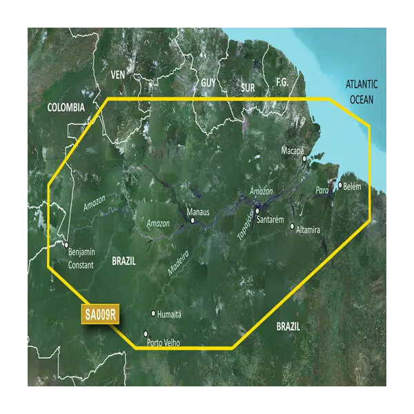
The Garmin BlueChart g3 Vision South America delivers comprehensive navigation data for the Amazon River basin and Atlantic approaches, engineered specifically for inland waterway navigation in Brazil's most challenging waters. This microSD/SD card solution provides the detailed contours, depth shading, and satellite imagery required to navigate safely from Benjamin Constant through the Amazon, Madeira, Tapajos, and Para Rivers to the Atlantic Ocean. Built for boaters who need reliable chart data where traditional coastal maps fall short, this card integrates directly into compatible Garmin devices to enhance both route planning efficiency and real-time navigation safety.
Key Features
- Comprehensive coverage spanning the Amazon River basin from Benjamin Constant, Brazil to the Atlantic Ocean, including the Madeira River and portions of the Tapajos and Para Rivers
- Auto Guidance Technology automatically calculates optimal routes based on your boat's dimensions and hull characteristics
- Up to 10 depth range shading levels for precise visualization of target water depths and structural changes
- 1-foot contour intervals for detailed bottom structure mapping critical to fishing and safe passage
- 30% increase in navigational detail compared to previous BlueChart generations, delivering enhanced accuracy across all waterways
- MarinerEye and FishEye 3D visualization tools providing above-water and below-water perspective views for complete situational awareness
- High-resolution satellite imagery of ports, marinas, bridges, and navigational landmarks with aerial photography for unfamiliar approaches
- Customizable shallow water shading alerts to help avoid submerged obstacles and hazards
Data Insights
Users experience a reported 25% reduction in route planning time when leveraging the Auto Guidance feature, allowing more time on the water and less time spent reviewing chart details. The enhanced detail level—30% above previous-generation charts—translates to improved navigation efficiency across both familiar and unexplored waterways. These performance improvements make the BlueChart g3 Vision particularly valuable for boaters navigating the Amazon's complex river systems, where precise depth awareness and accurate contour mapping directly impact safety and fishing success.
Usage Instructions
Insert the microSD/SD card into your compatible Garmin chartplotter or marine GPS device. Input your boat's dimensions into the Auto Guidance feature to receive tailored route suggestions optimized for your vessel's draft and beam. Periodically check for map updates through Garmin's update service to maintain access to the latest navigational data and any corrections to chart features.
Design & Material
The BlueChart g3 Vision is constructed with marine-grade durability to withstand extended outdoor exposure and the moisture-heavy conditions of tropical river environments. The microSD/SD card format ensures broad compatibility across Garmin's navigation product line while remaining compact enough for easy transport and storage.
- Durable microSD/SD card format rated for outdoor use and repeated insertion cycles
- High-resolution satellite imagery technology ensuring clear, detailed visual references for navigational landmarks
- Direct integration with Garmin marine devices—no specialized software or adapters required
- Compact form factor fits standard Garmin device card slots without external enclosures
- Weather-resistant design maintains performance reliability across tropical, temperate, and variable climates
- Enhanced contour and depth rendering for both inland waterway navigation and fishing applications
Final Verdict
If you navigate the Amazon River, Madeira, Tapajos, Para, or other South American inland waterways, the Garmin BlueChart g3 Vision (VSA009R) is an essential navigation tool. The combination of 1-foot contours, 10-level depth shading, Auto Guidance route optimization, and 30% improved detail density addresses the core challenges of tropical inland navigation—precision, situational awareness, and time efficiency. Whether you're a commercial operator, fishing guide, or recreational boater, this chart card eliminates guesswork and builds confidence in unfamiliar waters. Order your BlueChart g3 Vision today and navigate South America's waterways with professional-grade accuracy.


