


Garmin South America, East Coast Charts BlueChart g3 | HXSA001R | microSD/SD
Garmin South America, East Coast Charts BlueChart g3 | HXSA001R | microSD/SD
Model Number: 010-C1062-20
In stock
 WhatsApp
 SMS - Text us!
 Email Us!
 Help Desk

Tech Specs
In The Box
Do you have an old GPS unit lying around? The GPS Nation Trade In and Up program is a great way to trade in your old and used GPS for credit towards a new GPS. The choice is entirely yours! We’ve made the process simple and streamlined. Follow these simple steps, and you will be on your way to receiving credit towards your brand new GPS!
1. Get a quote
To get your free quote, provide your GPS type, manufacturer, model, and condition. Within 24 hours, you will receive a quote for the trade-in value of your current product. The GPS trade-in/trade-up form is at the bottom of this page.
2. Ship your product(s) for trade
After accepting our offer, pack your product(s) safely and ship them to us using the pre-paid shipping label provided to you. We will provide a confirmation email when your trade-in arrives at our warehouse. You have 30 days from the date you complete your on-line trade to ship the product to GPS Nation.
3. Make your purchase
Once we receive your product at our warehouse and we validate the stated condition, we will send you a confirmation email. If you elect to receive credit towards a new GPS at gpsnation.com, your store credit will be issued, and you are free to make your purchase.
Manual & Warranty
 Garmin Warranty
Reviews
Ask a Question
Tech Specs
In The Box
Trade-In
Do you have an old GPS unit lying around? The GPS Nation Trade In and Up program is a great way to trade in your old and used GPS for credit towards a new GPS. The choice is entirely yours! We’ve made the process simple and streamlined. Follow these simple steps, and you will be on your way to receiving credit towards your brand new GPS!
1. Get a quote
To get your free quote, provide your GPS type, manufacturer, model, and condition. Within 24 hours, you will receive a quote for the trade-in value of your current product. The GPS trade-in/trade-up form is at the bottom of this page.
2. Ship your product(s) for trade
After accepting our offer, pack your product(s) safely and ship them to us using the pre-paid shipping label provided to you. We will provide a confirmation email when your trade-in arrives at our warehouse. You have 30 days from the date you complete your on-line trade to ship the product to GPS Nation.
3. Make your purchase
Once we receive your product at our warehouse and we validate the stated condition, we will send you a confirmation email. If you elect to receive credit towards a new GPS at gpsnation.com, your store credit will be issued, and you are free to make your purchase.
Manual & Warranty
Overview
Garmin South America East Coast Charts BlueChart g3 microSD/SD Card Navigation Map (HXSA001R)
Introduction
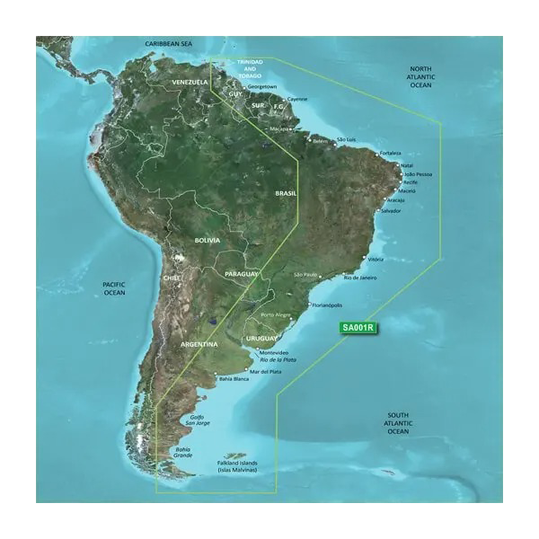
The Garmin South America, East Coast Charts BlueChart g3 is a high-resolution marine navigation chart delivered on microSD/SD card that transforms how you navigate the Atlantic-facing waters from Golfo de Paria in the north through Tierra del Fuego, including the Falkland Islands. Built from official charts and private hydrographic sources, this chart combines precise bathymetric data with satellite imagery to deliver situational awareness and safety advantages whether you're conducting commercial operations or recreational cruising along one of the world's most geographically diverse coastlines.
Key Features
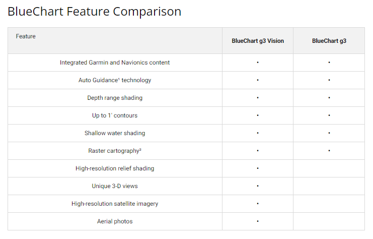
- Depth range shading with up to 10 customizable shallow-water categories for immediate visual hazard identification
- High-resolution bottom contours down to 1-foot intervals, enabling accurate detection of structure critical for both navigation safety and fishing applications
- Garmin Auto Guidance route calculation that factors vessel dimensions, draft, and beam to recommend optimal tracklines automatically
- MarinerEye and FishEye 3D perspectives offering above-water landmark visualization and below-water structure mapping in a single view
- Crystal-clear satellite imagery integrated with chart data for precise identification of harbors, breakwaters, and coastal landmarks
- Navigational aids including spot soundings, tide and current datasets, and detailed harbor information for ports spanning the full coverage area
Data Insights
Mariners using BlueChart g3 charts report route efficiency improvements of up to 30 percent, translating directly to fuel savings and reduced transit time across multi-day passages. The precision depth contours combined with high-resolution satellite overlay eliminate the guesswork in approach planning and significantly improve confidence when navigating complex estuaries, archipelagos, and shallow-water anchorages common throughout South America's Atlantic coast. This data fusion creates a navigational advantage particularly valuable in remote areas where detailed paper charts may be outdated or incomplete.
Usage Instructions
Insert the microSD/SD card into any compatible Garmin chartplotter or marine GPS device and verify your device runs the latest software version for full feature support. Access the Auto Guidance feature by plotting a destination waypoint, then allow the system to calculate your route based on your vessel's specifications. Customize depth range shading to match your draft requirements, and use the 3D view modes to preview coastal approaches and identify potential holding ground before commitment.
Design & Material
This chart card is engineered specifically for saltwater marine environments, combining robust microSD/SD card hardware with comprehensive chart software in a single compact package that integrates seamlessly into your existing Garmin ecosystem. The interface prioritizes immediate access to critical navigation data without unnecessary menu depth, allowing quick adjustments underway.
- MicroSD/SD card media constructed for marine moisture and temperature extremes with multi-year data retention
- Full coverage of South American Atlantic coast from Venezuela to Cape Horn, including inland passages like Río de la Plata
- New Chart Guarantee program providing regular updates as official hydrographic surveys and corrections are released
- Comprehensive harbor charts with approach vectors, tide stations, and current data for major ports including Rio de Janeiro, Buenos Aires, and Montevideo
- Compatibility confirmed across Garmin GPSMAP, echoMAP, and Fusion marine device families manufactured within the last 10 years
- Chart data derived from multiple authoritative sources including national hydrographic offices and commercial survey data for cross-validation
Final Verdict
The BlueChart g3 South America chart card eliminates navigational uncertainty for anyone planning extended coastal or offshore operations along the Atlantic side of South America. Whether you're positioning a vessel, fishing unfamiliar grounds, or transit cruising from the Caribbean to Patagonia, the combination of 1-foot contours, Auto Guidance routing, and satellite-verified harbor information delivers the situational awareness that separates confident passage planning from risky guesswork. Ensure your Garmin device is equipped with this chart before your next South American voyage.


