


Garmin South China Sea Coastal Charts BlueChart g3 | HXAE004R | microSD/SD
Garmin South China Sea Coastal Charts BlueChart g3 | HXAE004R | microSD/SD
Model Number: 010-C0879-20
In stock
 WhatsApp
 SMS - Text us!
 Email Us!
 Help Desk

Tech Specs

In The Box
Do you have an old GPS unit lying around? The GPS Nation Trade In and Up program is a great way to trade in your old and used GPS for credit towards a new GPS. The choice is entirely yours! We’ve made the process simple and streamlined. Follow these simple steps, and you will be on your way to receiving credit towards your brand new GPS!
1. Get a quote
To get your free quote, provide your GPS type, manufacturer, model, and condition. Within 24 hours, you will receive a quote for the trade-in value of your current product. The GPS trade-in/trade-up form is at the bottom of this page.
2. Ship your product(s) for trade
After accepting our offer, pack your product(s) safely and ship them to us using the pre-paid shipping label provided to you. We will provide a confirmation email when your trade-in arrives at our warehouse. You have 30 days from the date you complete your on-line trade to ship the product to GPS Nation.
3. Make your purchase
Once we receive your product at our warehouse and we validate the stated condition, we will send you a confirmation email. If you elect to receive credit towards a new GPS at gpsnation.com, your store credit will be issued, and you are free to make your purchase.
Manual & Warranty
 Garmin Warranty
Reviews
Ask a Question
Tech Specs
In The Box
Trade-In
Do you have an old GPS unit lying around? The GPS Nation Trade In and Up program is a great way to trade in your old and used GPS for credit towards a new GPS. The choice is entirely yours! We’ve made the process simple and streamlined. Follow these simple steps, and you will be on your way to receiving credit towards your brand new GPS!
1. Get a quote
To get your free quote, provide your GPS type, manufacturer, model, and condition. Within 24 hours, you will receive a quote for the trade-in value of your current product. The GPS trade-in/trade-up form is at the bottom of this page.
2. Ship your product(s) for trade
After accepting our offer, pack your product(s) safely and ship them to us using the pre-paid shipping label provided to you. We will provide a confirmation email when your trade-in arrives at our warehouse. You have 30 days from the date you complete your on-line trade to ship the product to GPS Nation.
3. Make your purchase
Once we receive your product at our warehouse and we validate the stated condition, we will send you a confirmation email. If you elect to receive credit towards a new GPS at gpsnation.com, your store credit will be issued, and you are free to make your purchase.
Manual & Warranty
Overview
Garmin South China Sea Coastal Charts BlueChart g3 microSD/SD Card (HXAE004R)
Introduction
The Garmin South China Sea Coastal Charts BlueChart g3 delivers precise navigation data across one of the world's most complex maritime regions. Built on official charting data and private marine sources, this microSD/SD card provides mariners with the depth accuracy, harbor detail, and underwater contour mapping required for safe passage through Southeast Asian waters spanning over 1,000 nautical miles of coastline.
Key Features
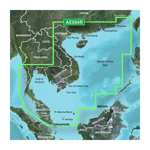
- Coverage area spanning the Malay Peninsula, Thailand, Cambodia, Vietnam, China (including Hainan Island), extending to Quanzhou with general coastal detail across all major shipping routes and anchorages
- Up to 10 distinct depth range shading levels for rapid visual identification of target fishing zones and safe water columns
- 1-foot contour intervals designed specifically for shallow-water navigation in canals, swamps, and marina approaches where standard contours lack precision
- Spot soundings and detailed bathymetry data derived from official navigation charts and marine surveys for accurate underwater terrain assessment
- High-resolution harbor and marina details including facility locations, breakwaters, turning basins, and anchorage positions throughout the South China Sea region
- User-customizable shallow water shading with adjustable depth thresholds to match your vessel's draft and operational requirements
- MicroSD/SD card format compatible with all current Garmin marine GPS units and chartplotters for immediate deployment
- New Chart Guarantee program with discount update pricing to keep your navigation data current as survey data improves
Data Insights
The Garmin BlueChart g3 South China Sea charts maintain accuracy standards that significantly reduce navigation risk in a region where variable bathymetry and shifting anchorage conditions present real hazards. The 1-foot contour resolution in shallow areas represents a 12-fold increase in detail compared to standard 12-foot contours used in broader coverage products. Coverage extends across fishing grounds, shipping lanes, and coastal approaches where depth variation can shift dramatically within single nautical mile intervals—a level of precision that directly impacts both fuel efficiency and safety for commercial and recreational vessels operating these waters.
Usage Instructions
Insert the microSD/SD card into your compatible Garmin chartplotter or marine GPS unit, then initialize the chart through your device menu. Ensure your Garmin device runs current firmware to access all chart features including the interactive depth shading controls. Customize the shallow water alarm thresholds and depth range colors within your unit's settings to match your specific vessel draft and operating conditions. Familiarize yourself with the chart's harbor detail and spot soundings before entering congested anchorages or narrow passages.
Design & Material
The BlueChart g3 chart card features a compact microSD/SD format designed for quick installation and minimal storage footprint aboard vessel navigation consoles. The card construction withstands salt spray, temperature fluctuations, and humidity exposure inherent to marine environments without degradation of stored chart data or card functionality.
- MicroSD/SD card format engineered for marine use with protective casing and corrosion-resistant contacts rated for saltwater exposure
- High-resolution vector chart display optimized for 5-inch to 16-inch Garmin marine touchscreen and traditional button-based interfaces
- Advanced bathymetric rendering with layered depth shading that remains legible in bright sunlight and low-light navigation scenarios
- Precision data sourced from official charting authorities combined with verified private marine surveys conducted by regional hydrographic specialists
- Lightweight, portable card format allows easy transport between vessels or backup chart storage for extended offshore operations
- Plug-and-play installation requiring no software updates or computer configuration—immediate chart availability upon card insertion
Final Verdict
For mariners operating commercial vessels, fishing boats, or cruising sailboats through the South China Sea, the Garmin BlueChart g3 HXAE004R represents the navigation investment that directly correlates to fuel economy, passage safety, and operational efficiency. The combination of 1-foot contour detail, customizable depth shading, and comprehensive harbor mapping addresses the specific challenges of this congested maritime region. Upgrade your Garmin chartplotter today with this regionally tailored chart card and navigate with confidence through the waters where precision matters most.


