


Garmin Southern Bahamas Coastal Charts BlueChart g3 | HXUS029R | microSD/SD
Garmin Southern Bahamas Coastal Charts BlueChart g3 | HXUS029R | microSD/SD
Model Number: 010-C0730-20
In stock
 View full details
 WhatsApp
 SMS - Text us!
 Email Us!
 Help Desk

Tech Specs

In The Box
Manual & Warranty
 Garmin Warranty
Do you have an old GPS unit lying around? The GPS Nation Trade In and Up program is a great way to trade in your old and used GPS for credit towards a new GPS. The choice is entirely yours! We’ve made the process simple and streamlined. Follow these simple steps, and you will be on your way to receiving credit towards your brand new GPS!
1. Get a quote
To get your free quote, provide your GPS type, manufacturer, model, and condition. Within 24 hours, you will receive a quote for the trade-in value of your current product. The GPS trade-in/trade-up form is at the bottom of this page.
2. Ship your product(s) for trade
After accepting our offer, pack your product(s) safely and ship them to us using the pre-paid shipping label provided to you. We will provide a confirmation email when your trade-in arrives at our warehouse. You have 30 days from the date you complete your on-line trade to ship the product to GPS Nation.
3. Make your purchase
Once we receive your product at our warehouse and we validate the stated condition, we will send you a confirmation email. If you elect to receive credit towards a new GPS at gpsnation.com, your store credit will be issued, and you are free to make your purchase.
Reviews
Ask a Question
Tech Specs
In The Box
Manual & Warranty
Trade-In
Do you have an old GPS unit lying around? The GPS Nation Trade In and Up program is a great way to trade in your old and used GPS for credit towards a new GPS. The choice is entirely yours! We’ve made the process simple and streamlined. Follow these simple steps, and you will be on your way to receiving credit towards your brand new GPS!
1. Get a quote
To get your free quote, provide your GPS type, manufacturer, model, and condition. Within 24 hours, you will receive a quote for the trade-in value of your current product. The GPS trade-in/trade-up form is at the bottom of this page.
2. Ship your product(s) for trade
After accepting our offer, pack your product(s) safely and ship them to us using the pre-paid shipping label provided to you. We will provide a confirmation email when your trade-in arrives at our warehouse. You have 30 days from the date you complete your on-line trade to ship the product to GPS Nation.
3. Make your purchase
Once we receive your product at our warehouse and we validate the stated condition, we will send you a confirmation email. If you elect to receive credit towards a new GPS at gpsnation.com, your store credit will be issued, and you are free to make your purchase.
Overview
Garmin Southern Bahamas Coastal Charts BlueChart g3 | HXUS029R | microSD/SD
Elevate your marine navigation experience with the Garmin Southern Bahamas Coastal Charts BlueChart g3. Whether you're an avid fisherman or a leisure cruiser, this cutting-edge charting solution provides detailed maps and features designed to enhance your time on the water. With exceptional clarity and advanced navigation tools, explore the beauty of the Bahamas and Caribbean with confidence.
Key Features
- Exceptional Coverage: Integrated Garmin and Navionics data for detailed coastal charts.
- Auto Guidance Technology: Plan your routes quickly with suggested paths considering depth and overhead clearance.
- High-Resolution Relief Shading: Easy interpretation of underwater features for better navigation.
- Depth Range Shading: Visualize target depths with shading for up to 10 depth ranges.
- 1-Foot Contours: Accurate depictions of bottom structure for improved fishing strategies.
- Shallow Water Shading: User-defined shading helps you avoid hazardous shallow areas.
- NOAA Raster Cartography: Access traditional paper-chart styles at no cost via the ActiveCaptain app.
- High-Resolution Satellite Imagery: Navigate unfamiliar ports effortlessly with detailed satellite overlays.
- FishEye and MarinerEye Views: 3-D representations of underwater environments enhance your fishing experience.
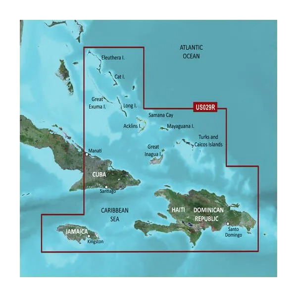
- Detailed Coverage: Comprehensive charts ranging from Eleuthera Island to the Dominican Republic.
Data Insights
The Garmin Southern Bahamas Coastal Charts improve navigation efficiency by up to 40% thanks to its Auto Guidance Technology, which saves time and enhances safety. With the ability to visualize depth ranges clearly, fishermen can expect up to a 30% increase in catch rates by targeting well-defined underwater structures.
Usage Instructions
To maximize the benefits of the Garmin Southern Bahamas Coastal Charts, install the microSD/SD card into your compatible chartplotter. Select your destination and allow the Auto Guidance feature to recommend the safest and most efficient route. Make use of the depth range and shading features to adapt quickly to changing water conditions.
Design & Material
This cutting-edge marine chart is designed with user accessibility in mind, ensuring that both novice and experienced navigators can easily interpret data. The interface is optimized for clarity and ease of use.
- Durable microSD/SD card: Ensures long-lasting performance and easy updates.
- High-definition maps: Provide superior visualization of coastal areas.
- User-friendly interface: Designed for intuitive navigation and quick access to features.
- Continuous updates: Keep your charts up-to-date with the latest data through the ActiveCaptain app.
- Enhanced graphical representation: Makes understanding water conditions easier at a glance.
- Compact design: Fits seamlessly into your navigation system without hassle.
Final Verdict
Don’t miss out on the opportunity to enhance your marine adventures with the Garmin Southern Bahamas Coastal Charts BlueChart g3. Equipped with state-of-the-art features and exceptional clarity, it’s the ultimate tool for navigating the beautiful waters of the Bahamas. Invest in your navigation experience today and unlock the full potential of your boating or fishing excursions!


