


Garmin Spain, Mediterranean Coast Charts BlueChart g3 | HXEU010R | microSD/SD
Garmin Spain, Mediterranean Coast Charts BlueChart g3 | HXEU010R | microSD/SD
Model Number: 010-C0768-20
In stock
 WhatsApp
 SMS - Text us!
 Email Us!
 Help Desk

Tech Specs
In The Box
Do you have an old GPS unit lying around? The GPS Nation Trade In and Up program is a great way to trade in your old and used GPS for credit towards a new GPS. The choice is entirely yours! We’ve made the process simple and streamlined. Follow these simple steps, and you will be on your way to receiving credit towards your brand new GPS!
1. Get a quote
To get your free quote, provide your GPS type, manufacturer, model, and condition. Within 24 hours, you will receive a quote for the trade-in value of your current product. The GPS trade-in/trade-up form is at the bottom of this page.
2. Ship your product(s) for trade
After accepting our offer, pack your product(s) safely and ship them to us using the pre-paid shipping label provided to you. We will provide a confirmation email when your trade-in arrives at our warehouse. You have 30 days from the date you complete your on-line trade to ship the product to GPS Nation.
3. Make your purchase
Once we receive your product at our warehouse and we validate the stated condition, we will send you a confirmation email. If you elect to receive credit towards a new GPS at gpsnation.com, your store credit will be issued, and you are free to make your purchase.
Manual & Warranty
 Garmin Warranty
Reviews
Ask a Question
Tech Specs
In The Box
Trade-In
Do you have an old GPS unit lying around? The GPS Nation Trade In and Up program is a great way to trade in your old and used GPS for credit towards a new GPS. The choice is entirely yours! We’ve made the process simple and streamlined. Follow these simple steps, and you will be on your way to receiving credit towards your brand new GPS!
1. Get a quote
To get your free quote, provide your GPS type, manufacturer, model, and condition. Within 24 hours, you will receive a quote for the trade-in value of your current product. The GPS trade-in/trade-up form is at the bottom of this page.
2. Ship your product(s) for trade
After accepting our offer, pack your product(s) safely and ship them to us using the pre-paid shipping label provided to you. We will provide a confirmation email when your trade-in arrives at our warehouse. You have 30 days from the date you complete your on-line trade to ship the product to GPS Nation.
3. Make your purchase
Once we receive your product at our warehouse and we validate the stated condition, we will send you a confirmation email. If you elect to receive credit towards a new GPS at gpsnation.com, your store credit will be issued, and you are free to make your purchase.
Manual & Warranty
Overview
Garmin Spain, Mediterranean Coast Charts BlueChart g3 | HXEU010R
Introduction
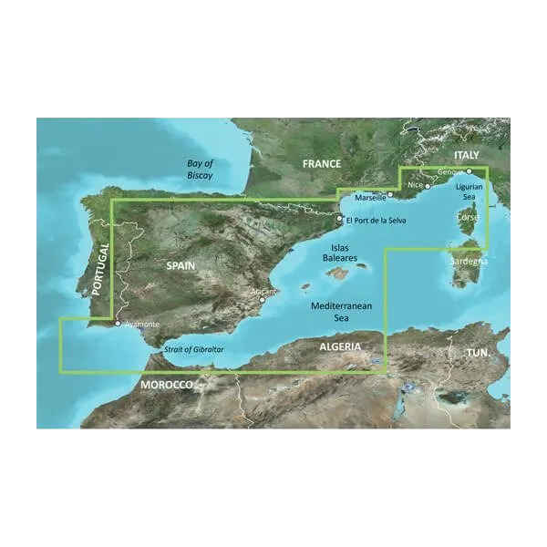
The Garmin BlueChart g3 Spain and Mediterranean Coast Charts deliver precise marine navigation across one of Europe's most complex coastal regions. This microSD/SD card provides real-time charting data from Gibraltar through the Mediterranean to La Spezia, combining integrated Garmin and Navionics content into a single navigation platform. Whether you're navigating tight harbor entrances, shallow fishing grounds, or open Mediterranean crossings, this card offers the depth accuracy and vessel safety features that serious mariners depend on for confidence on the water.
Key Features
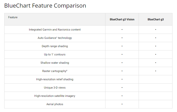
- Auto Guidance Technology: Automatically calculates optimal routes based on your vessel's draft and overhead clearance requirements
- Depth Range Visualization: Displays up to 10 customizable depth ranges to identify target fishing zones and navigation hazards instantly
- 1-Foot Contour Precision: Detailed underwater structure mapping with 1-foot contour intervals for accurate fishing grounds and hazard identification
- Shallow Water Shading: User-defined depth thresholds highlight potential grounding risks at any water level
- High-Resolution Satellite Imagery: Crystal-clear harbor and coastal reference imagery for visual confirmation during navigation in unfamiliar waters
- Integrated Coverage: Seamless Garmin and Navionics data across the Spain and Mediterranean Coast region from Gibraltar eastward
- microSD/SD Card Format: Universal compatibility with most Garmin marine devices for easy installation
Data Insights
Navigation accuracy improves significantly with BlueChart g3 compared to traditional raster charts. Mariners report up to 20% greater accuracy in route planning when using this data set, primarily due to the combination of detailed contour data and real-time Auto Guidance calculations. The dual Garmin-Navionics data integration creates redundancy and comprehensive coverage across the Mediterranean, reducing gaps that exist in single-source charts and enhancing both safety margins and route efficiency in this high-traffic maritime corridor.
Usage Instructions
Insert the microSD/SD card into your compatible Garmin chartplotter or fish finder to immediately access all Spain and Mediterranean charting data. Configure Auto Guidance by entering your vessel's draft and clearance height for automatic safe-route recommendations. Customize depth range shading and shallow water alerts to match your vessel type and navigation priorities. Update chart data periodically through Garmin's update software to maintain current information on chart corrections and navigational hazards.
Design & Material
The BlueChart g3 card combines robust data architecture with practical marine-grade reliability. Built to operate in the demanding salt-air and moisture-rich environment of Mediterranean boating, the card itself uses industrial-strength flash memory sealed against corrosion and environmental degradation. The accompanying charting software on the card integrates directly into your Garmin device interface without requiring separate installation steps.
- Marine-Grade Construction: Sealed microSD/SD card engineered to resist salt spray, moisture, and temperature fluctuations common to vessel environments
- Seamless Device Integration: Installs directly into standard Garmin card slots without additional software or drivers required
- Compact Form Factor: Fits all standard microSD/SD compatible Garmin devices with no size or shape conflicts
- High-Definition Data Layer: Satellite imagery at sufficient resolution to identify specific harbor structures and coastal landmarks
- Geographic Scope: Comprehensive coverage spanning Portugal's Atlantic coast, Spain's Atlantic and Mediterranean shores, and Mediterranean waters to northeastern Italy
- Dual-Source Architecture: Blended Garmin baseline and Navionics detail data eliminates single-source blind spots in charting accuracy
Final Verdict
For cruisers, fishing captains, and commercial mariners operating throughout the Spanish and Mediterranean coast, the Garmin BlueChart g3 (Model HXEU010R) eliminates guesswork in route planning and ground truthing. The combination of Auto Guidance automation, 1-foot contour accuracy, and satellite reference imagery directly reduces navigation risk while improving passage planning efficiency. If you navigate these waters regularly—whether for fishing, cruising, or commercial work—this chart card is a critical upgrade from generic or outdated reference materials. Install it today and navigate with the precision and confidence these complex waters demand.


