


Garmin Sweden, Southeast Coastal and Inland Charts BlueChart g3 | HXEU046R | microSD/SD
Garmin Sweden, Southeast Coastal and Inland Charts BlueChart g3 | HXEU046R | microSD/SD
Model Number: 010-C0782-20
In stock
 WhatsApp
 SMS - Text us!
 Email Us!
 Help Desk

Tech Specs

In The Box
Do you have an old GPS unit lying around? The GPS Nation Trade In and Up program is a great way to trade in your old and used GPS for credit towards a new GPS. The choice is entirely yours! We’ve made the process simple and streamlined. Follow these simple steps, and you will be on your way to receiving credit towards your brand new GPS!
1. Get a quote
To get your free quote, provide your GPS type, manufacturer, model, and condition. Within 24 hours, you will receive a quote for the trade-in value of your current product. The GPS trade-in/trade-up form is at the bottom of this page.
2. Ship your product(s) for trade
After accepting our offer, pack your product(s) safely and ship them to us using the pre-paid shipping label provided to you. We will provide a confirmation email when your trade-in arrives at our warehouse. You have 30 days from the date you complete your on-line trade to ship the product to GPS Nation.
3. Make your purchase
Once we receive your product at our warehouse and we validate the stated condition, we will send you a confirmation email. If you elect to receive credit towards a new GPS at gpsnation.com, your store credit will be issued, and you are free to make your purchase.
Manual & Warranty
Reviews
Ask a Question
Tech Specs
In The Box
Trade-In
Do you have an old GPS unit lying around? The GPS Nation Trade In and Up program is a great way to trade in your old and used GPS for credit towards a new GPS. The choice is entirely yours! We’ve made the process simple and streamlined. Follow these simple steps, and you will be on your way to receiving credit towards your brand new GPS!
1. Get a quote
To get your free quote, provide your GPS type, manufacturer, model, and condition. Within 24 hours, you will receive a quote for the trade-in value of your current product. The GPS trade-in/trade-up form is at the bottom of this page.
2. Ship your product(s) for trade
After accepting our offer, pack your product(s) safely and ship them to us using the pre-paid shipping label provided to you. We will provide a confirmation email when your trade-in arrives at our warehouse. You have 30 days from the date you complete your on-line trade to ship the product to GPS Nation.
3. Make your purchase
Once we receive your product at our warehouse and we validate the stated condition, we will send you a confirmation email. If you elect to receive credit towards a new GPS at gpsnation.com, your store credit will be issued, and you are free to make your purchase.
Manual & Warranty
Overview
Garmin BlueChart g3 Sweden Southeast Coastal and Inland Charts HXEU046R
Introduction
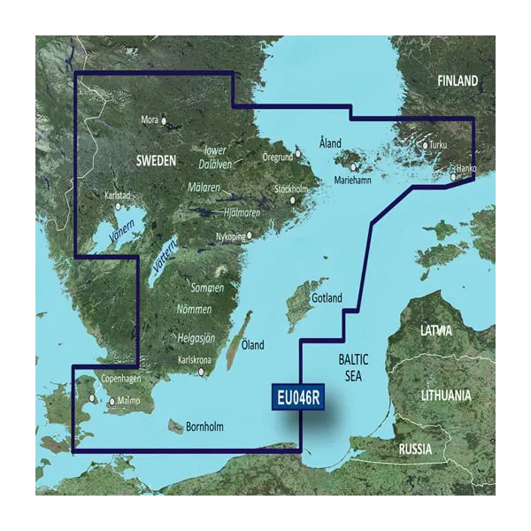
The Garmin BlueChart g3 (model HXEU046R) delivers comprehensive navigation coverage for Sweden's coastal waters and inland systems, integrating Garmin and Navionics content to provide the clarity and accuracy required for confident boating across the Baltic Sea, archipelagos, and Scandinavian waterways. This microSD/SD card-based chart product combines high-resolution bathymetric detail with satellite imagery overlay, enabling users to identify structure, avoid hazards, and plan efficient routes through complex Swedish and Southeast Baltic waters.
Key Features
- Integrated Garmin and Navionics charting content with up to 30% more coastal detail than previous-generation charts
- 1-foot contour intervals for precise underwater topography representation and structure identification
- Up to 10 user-selectable depth range shading levels to highlight target fishing depths and navigate shallow waters safely
- Auto Guidance Technology that calculates optimal routes based on specified depth clearance and overhead obstruction parameters
- High-resolution satellite imagery overlay for visual reference in unfamiliar ports, harbors, and marina approaches across the coverage area
- 3D perspective modes (FishEye and MarinerEye) for immersive underwater structure visualization and 360-degree surrounding awareness
- Shallow water shading with user-defined parameters to identify and avoid obstacles in coastal and archipelago areas
- Comprehensive aerial photography of Swedish ports, Baltic harbors, and marina facilities for enhanced approach navigation
Data Insights
Users gain access to a 30% increase in coastal detail density compared to earlier BlueChart generations, with bathymetric accuracy meeting professional marine charting standards. The dual-source integration ensures consistent data quality and frequent updates, making this chart essential for both recreational fishers seeking specific depth zones and commercial operators requiring reliable navigation throughout Swedish and Southeast Baltic territories.
Usage Instructions
Insert the microSD/SD card into your compatible Garmin chart plotter or echosounder and ensure your device firmware is current to unlock all BlueChart g3 features. Activate Auto Guidance to calculate safe routes tailored to your vessel's draft and air-draft specifications, customize depth range shading to match your fishing or navigation priorities, and utilize satellite imagery overlays when approaching unfamiliar docking areas or navigating complex archipelago passages.
Design and Material
The BlueChart g3 is engineered for reliability in marine environments, with seamless integration into Garmin's ecosystem of chart plotters and sonar units. The microSD/SD format provides durability without moving parts, ensuring long-term data integrity aboard vessels exposed to saltwater spray, vibration, and temperature fluctuations.
- Robust microSD/SD card construction withstands marine corrosion and physical stress
- Compact form factor for easy storage and transport between devices
- Intuitive interface designed for one-handed operation in challenging sea conditions
- High-resolution vector charting combined with raster satellite imagery for dual-mode navigation
- Regular content updates delivered through Garmin's software platform to maintain accuracy and regulatory compliance
- Universal compatibility with current and legacy Garmin chart plotter models across recreational and professional marine sectors
Final Verdict
The Garmin BlueChart g3 HXEU046R is indispensable for anyone navigating Swedish waters, from shallow-draft inland fisheries to open-water Baltic passages. The combination of 1-foot contours, intelligent routing assistance, and satellite-verified charting eliminates guesswork and significantly reduces navigation risk. If you depend on your boat for fishing, cruising, or commercial operations in Scandinavian and Baltic regions, this chart upgrade delivers the precision and situational awareness that separate safe, efficient trips from uncertain ones. Add the BlueChart g3 to your Garmin system now and gain the competitive advantage of professional-grade navigation data.


