


Garmin Sweden, Stromstad to Halmstad Charts BlueChart g3 Vision | VEU470S | microSD™/SD™
Garmin Sweden, Stromstad to Halmstad Charts BlueChart g3 Vision | VEU470S | microSD™/SD™
Model Number: 010-C0814-00
In stock
 WhatsApp
 SMS - Text us!
 Email Us!
 Help Desk

Tech Specs

In The Box
Do you have an old GPS unit lying around? The GPS Nation Trade In and Up program is a great way to trade in your old and used GPS for credit towards a new GPS. The choice is entirely yours! We’ve made the process simple and streamlined. Follow these simple steps, and you will be on your way to receiving credit towards your brand new GPS!
1. Get a quote
To get your free quote, provide your GPS type, manufacturer, model, and condition. Within 24 hours, you will receive a quote for the trade-in value of your current product. The GPS trade-in/trade-up form is at the bottom of this page.
2. Ship your product(s) for trade
After accepting our offer, pack your product(s) safely and ship them to us using the pre-paid shipping label provided to you. We will provide a confirmation email when your trade-in arrives at our warehouse. You have 30 days from the date you complete your on-line trade to ship the product to GPS Nation.
3. Make your purchase
Once we receive your product at our warehouse and we validate the stated condition, we will send you a confirmation email. If you elect to receive credit towards a new GPS at gpsnation.com, your store credit will be issued, and you are free to make your purchase.
Manual & Warranty
 Garmin Warranty
Reviews
Ask a Question
Tech Specs
In The Box
Trade-In
Do you have an old GPS unit lying around? The GPS Nation Trade In and Up program is a great way to trade in your old and used GPS for credit towards a new GPS. The choice is entirely yours! We’ve made the process simple and streamlined. Follow these simple steps, and you will be on your way to receiving credit towards your brand new GPS!
1. Get a quote
To get your free quote, provide your GPS type, manufacturer, model, and condition. Within 24 hours, you will receive a quote for the trade-in value of your current product. The GPS trade-in/trade-up form is at the bottom of this page.
2. Ship your product(s) for trade
After accepting our offer, pack your product(s) safely and ship them to us using the pre-paid shipping label provided to you. We will provide a confirmation email when your trade-in arrives at our warehouse. You have 30 days from the date you complete your on-line trade to ship the product to GPS Nation.
3. Make your purchase
Once we receive your product at our warehouse and we validate the stated condition, we will send you a confirmation email. If you elect to receive credit towards a new GPS at gpsnation.com, your store credit will be issued, and you are free to make your purchase.
Manual & Warranty
Overview
Garmin BlueChart g3 Vision VEU470S: Premium Swedish Coastal and Inland Charts on microSD Card
Introduction
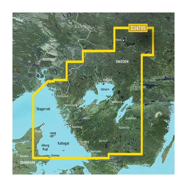
The Garmin BlueChart g3 Vision VEU470S delivers precision navigation for southwestern Swedish waters, from Stromstad to Halmstad, with integrated high-resolution satellite imagery and detailed bathymetric data. This microSD/SD card provides the depth clarity and route intelligence serious boaters and anglers need to navigate the Kattegat, Skagerrak, and connected inland lakes with confidence in a region known for complex underwater topography and narrow shipping channels.
Key Features
- Model 010-C0814-00: Compatible with all Garmin chartplotter systems supporting microSD/SD cards
- 30% more detailed charting compared to previous BlueChart generations, delivering higher precision in congested waters
- Up to 10 customizable depth range shadings, allowing anglers to isolate specific bottom depths for improved catch targeting
- 1-foot contour intervals for accurate bottom structure mapping across the entire coverage area
- Auto Guidance Technology that plots optimal routes based on vessel draft, beam width, and water depth thresholds
- High-resolution satellite imagery overlaid with navigational chart data for realistic contextual awareness of coastal landmarks and harbors
- Integrated Garmin and Navionics content ensuring current buoy positions, aid-to-navigation, and restricted area boundaries
- Shallow water customizable alerts with user-defined depth warnings for real-time safety monitoring
Data Insights
Navigation precision is critical in the Kattegat and Skagerrak, where traffic density and underwater hazards demand accurate charting. The VEU470S's 30% enhancement in detail over previous generations translates to finer contour resolution and more accurate depiction of submerged rocks, wrecks, and channel narrowings. The 1-foot contour intervals provide the granularity needed for both commercial transit and precision fishing in a region where depth changes rapidly and traditional paper charts lag behind real-time conditions.
Usage Instructions
Insert the microSD/SD card into your compatible Garmin chartplotter's card slot. The chart will activate automatically on your chart page. Enable Auto Guidance to receive route suggestions based on your vessel's draft and beam specifications, then adjust depth range shading to highlight your target fishing zones. Regularly cross-check your position against satellite overlay and buoy data, especially when transiting narrow channels or unfamiliar harbors along the Swedish coast.
Design & Material
The VEU470S is engineered for maritime durability. The microSD/SD card format balances portability with robust data storage, and Garmin's marine-grade design ensures reliable performance in salt spray, moisture-heavy environments typical of Scandinavian coastal operations.
- Durable microSD/SD card construction rated for saltwater environments and repeated insertion cycles
- Comprehensive coverage spanning Stromstad, Gothenburg, Kattegat shipping lanes, and inland lakes including Vänern and Vättern
- Dual-source cartography combining Garmin surveying data with Navionics bathymetric databases for cross-verified accuracy
- Compact card format reduces storage footprint while maintaining full resolution on compatible 7-inch and larger displays
- Real-time chart updates compatible with Garmin HomePort software for adding waypoints, routes, and fishing marks
- Realistic satellite backdrop enabling visual correlation between chart data and actual shoreline topology
Final Verdict
For boaters and commercial fishers operating in southwestern Sweden, the BlueChart g3 Vision VEU470S is a foundational navigation tool, not a luxury upgrade. The combination of 1-foot contours, satellite imagery, and Auto Guidance eliminates guesswork on waters where shallow drafts and narrow channels demand precision. Order the VEU470S today and upgrade from generic base maps to chart detail that reflects the complexity of Scandinavian coastal and lacustrine environments.


