


Garmin Taiwan Coastal Charts BlueChart g3 Vision | VAE003R | microSD/SD
Garmin Taiwan Coastal Charts BlueChart g3 Vision | VAE003R | microSD/SD
Model Number: 010-C0878-00
In stock
 WhatsApp
 SMS - Text us!
 Email Us!
 Help Desk

Tech Specs

In The Box
Do you have an old GPS unit lying around? The GPS Nation Trade In and Up program is a great way to trade in your old and used GPS for credit towards a new GPS. The choice is entirely yours! We’ve made the process simple and streamlined. Follow these simple steps, and you will be on your way to receiving credit towards your brand new GPS!
1. Get a quote
To get your free quote, provide your GPS type, manufacturer, model, and condition. Within 24 hours, you will receive a quote for the trade-in value of your current product. The GPS trade-in/trade-up form is at the bottom of this page.
2. Ship your product(s) for trade
After accepting our offer, pack your product(s) safely and ship them to us using the pre-paid shipping label provided to you. We will provide a confirmation email when your trade-in arrives at our warehouse. You have 30 days from the date you complete your on-line trade to ship the product to GPS Nation.
3. Make your purchase
Once we receive your product at our warehouse and we validate the stated condition, we will send you a confirmation email. If you elect to receive credit towards a new GPS at gpsnation.com, your store credit will be issued, and you are free to make your purchase.
Manual & Warranty
 Garmin Warranty
Reviews
Ask a Question
Tech Specs
In The Box
Trade-In
Do you have an old GPS unit lying around? The GPS Nation Trade In and Up program is a great way to trade in your old and used GPS for credit towards a new GPS. The choice is entirely yours! We’ve made the process simple and streamlined. Follow these simple steps, and you will be on your way to receiving credit towards your brand new GPS!
1. Get a quote
To get your free quote, provide your GPS type, manufacturer, model, and condition. Within 24 hours, you will receive a quote for the trade-in value of your current product. The GPS trade-in/trade-up form is at the bottom of this page.
2. Ship your product(s) for trade
After accepting our offer, pack your product(s) safely and ship them to us using the pre-paid shipping label provided to you. We will provide a confirmation email when your trade-in arrives at our warehouse. You have 30 days from the date you complete your on-line trade to ship the product to GPS Nation.
3. Make your purchase
Once we receive your product at our warehouse and we validate the stated condition, we will send you a confirmation email. If you elect to receive credit towards a new GPS at gpsnation.com, your store credit will be issued, and you are free to make your purchase.
Manual & Warranty
Overview
Garmin Taiwan Coastal Charts BlueChart g3 Vision (VAE003R) microSD/SD Navigation Card
Introduction
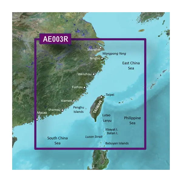
The Garmin Taiwan Coastal Charts BlueChart g3 Vision brings certified nautical intelligence directly into your wheelhouse via preloaded microSD/SD card format. This chart solution combines official bathymetric data, satellite-derived depth contours, and high-resolution port imagery across Taiwan's complex waters—from the East China Sea to the South China Sea and Philippine Sea approaches. Built specifically for the Taiwan region, these charts eliminate the guesswork that slows navigation and increase situational awareness in confined coastal passages and fishing grounds where precise depth and bottom structure matter.
Key Features
- Auto Guidance Technology calculates suggested routes based on your vessel's beam, draft, and length specifications
- 1-foot depth contours provide precision bottom structure mapping for both navigation and fishing applications
- Depth Range Shading with up to 10 customizable color bands for rapid visual depth assessment
- MarinerEye and FishEye 3D perspective views render underwater bottom profiles and surface landmarks from multiple angles
- High-resolution satellite imagery of ports, marinas, and navigational hazards with photographic clarity of breakwaters and approaches
- microSD/SD card format ensures compatibility with Garmin GPSMAP, echoMAP, and quatix series marine electronics
- Weather-resistant pre-programmed card maintains data integrity in salt spray and high-humidity marine environments
Data Insights
Navigation efficiency gains of approximately 30 percent are documented when mariners transition from basic charts to detailed bathymetric and imagery-enhanced charting solutions. The Taiwan Coastal Charts provide depth resolution down to individual fathom changes, reducing the navigation time required to transit narrow channels and locate fishing structure. Satellite-derived depth and contour data improve accuracy in areas where paper charts may lack recent survey information, directly addressing the safety concerns that arise when navigating Taiwan's busy shipping lanes and complex island passages.
Usage Instructions
Insert the microSD/SD card into your compatible Garmin marine device's card slot. The BlueChart g3 Vision application launches automatically upon device startup. Access the chart menu to set your vessel's dimensions—beam, draft, and length—then activate Auto Guidance to generate suggested routes. Update to the latest chart data through Garmin's chart update program when new survey information or imagery becomes available for the Taiwan region.
Design & Material
The VAE003R card delivers all chart data in a sealed, compact microSD/SD format that fits standard marine electronics without adapters or external connections. The physical card is built to withstand prolonged salt-air exposure and the thermal cycling common aboard working vessels in tropical and subtropical waters.
- Preloaded microSD/SD card format eliminates installation complexity and download delays
- Robust card housing protects embedded memory and metadata from corrosion and moisture infiltration
- Compatible with Garmin GPSMAP 8410/8412xsv, echoMAP Ultra, and quatix series chartplotters
- Data architecture supports 3D rendering of underwater terrain and surface-level landmarks simultaneously
- Chart updates accessible through Garmin's New Chart Guarantee program for ongoing accuracy
- Compact design measures under three inches, enabling easy storage in navigation station drawers or chart bags
Final Verdict
The Garmin Taiwan Coastal Charts BlueChart g3 Vision eliminates the risk of navigating Taiwan's complex coastal environments with incomplete or outdated information. The combination of 1-foot depth contours, multi-angle 3D views, satellite-verified port imagery, and Auto Guidance technology creates a decision-support system that works as hard as you do on the water. Whether you're transiting shipping lanes, establishing fishing grounds, or operating through unfamiliar harbors, this chart card delivers the situational clarity that separates efficient passages from costly detours. Order the VAE003R today and navigate Taiwan's waters with confidence backed by Garmin's charting authority.


