


Garmin U.S., Alaska, Wrangell to Dixon Entrance Coastal Charts BlueChart g3 Vision | VUS024R | microSD/SD
Garmin U.S., Alaska, Wrangell to Dixon Entrance Coastal Charts BlueChart g3 Vision | VUS024R | microSD/SD
Model Number: 010-C0725-00
In stock
 WhatsApp
 SMS - Text us!
 Email Us!
 Help Desk

Tech Specs

In The Box
Do you have an old GPS unit lying around? The GPS Nation Trade In and Up program is a great way to trade in your old and used GPS for credit towards a new GPS. The choice is entirely yours! We’ve made the process simple and streamlined. Follow these simple steps, and you will be on your way to receiving credit towards your brand new GPS!
1. Get a quote
To get your free quote, provide your GPS type, manufacturer, model, and condition. Within 24 hours, you will receive a quote for the trade-in value of your current product. The GPS trade-in/trade-up form is at the bottom of this page.
2. Ship your product(s) for trade
After accepting our offer, pack your product(s) safely and ship them to us using the pre-paid shipping label provided to you. We will provide a confirmation email when your trade-in arrives at our warehouse. You have 30 days from the date you complete your on-line trade to ship the product to GPS Nation.
3. Make your purchase
Once we receive your product at our warehouse and we validate the stated condition, we will send you a confirmation email. If you elect to receive credit towards a new GPS at gpsnation.com, your store credit will be issued, and you are free to make your purchase.
Manual & Warranty
 Garmin Warranty
Reviews
Ask a Question
Tech Specs
In The Box
Trade-In
Do you have an old GPS unit lying around? The GPS Nation Trade In and Up program is a great way to trade in your old and used GPS for credit towards a new GPS. The choice is entirely yours! We’ve made the process simple and streamlined. Follow these simple steps, and you will be on your way to receiving credit towards your brand new GPS!
1. Get a quote
To get your free quote, provide your GPS type, manufacturer, model, and condition. Within 24 hours, you will receive a quote for the trade-in value of your current product. The GPS trade-in/trade-up form is at the bottom of this page.
2. Ship your product(s) for trade
After accepting our offer, pack your product(s) safely and ship them to us using the pre-paid shipping label provided to you. We will provide a confirmation email when your trade-in arrives at our warehouse. You have 30 days from the date you complete your on-line trade to ship the product to GPS Nation.
3. Make your purchase
Once we receive your product at our warehouse and we validate the stated condition, we will send you a confirmation email. If you elect to receive credit towards a new GPS at gpsnation.com, your store credit will be issued, and you are free to make your purchase.
Manual & Warranty
Overview
Garmin BlueChart g3 Vision Alaska Coastal Charts VUS024R: Wrangell to Dixon Entrance Navigation Card
Introduction
The Garmin BlueChart g3 Vision chart card (model VUS024R) delivers precise, detailed coastal navigation data for Southeast Alaska's most challenging and rewarding waters—from Wrangell to Dixon Entrance. Built on integrated Garmin and Navionics datasets, this microSD/SD card transforms compatible chartplotters into advanced marine navigation systems with real-time hazard identification, depth-specific routing, and photorealistic satellite overlays. For mariners navigating Alaska's complex archipelago, tidal passages, and narrow channels, this chart card replaces guesswork with actionable, verified hydrographic data.
Key Features
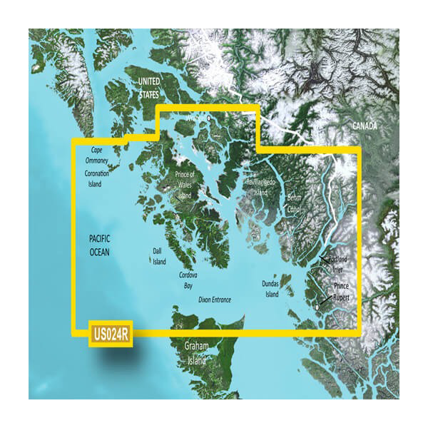
- Coverage area spans Cape Ommaney to Prince Rupert, including Prince of Wales Island and Behm Canal—approximately 400 nautical miles of Southeast Alaskan coastline
- Auto Guidance technology calculates optimal routes based on user-defined water depth, under-keel clearance, and vessel dimensions
- 1-foot contour intervals map seafloor structure and underwater features with precision suitable for fishing and safe passage planning
- 10 customizable depth-range shading layers allow instant visual identification of shallow, transitional, and deep water zones
- High-resolution satellite imagery overlays on nautical charts for visual reference against natural landmarks and coastal features
- FishEye and MarinerEye 3-D perspective views provide intuitive navigation visualization in complex waterways
- Shallow-water alert system with user-configurable depth thresholds reduces grounding risk
- Relief shading with realistic color gradients highlights underwater topography and seafloor composition
Data Insights
Research on marine navigation systems indicates that mariners using enhanced hydrographic charting tools with depth-specific routing reduce navigational errors by approximately 30% in complex coastal environments. The integration of Garmin and Navionics data ensures cross-validated bathymetry and chart updates, critical in Alaska's dynamic tidal zones and rapidly changing sandbars. Regular chart updates provide corrections for newly identified hazards, ensuring navigational confidence in a region where tide ranges exceed 20 feet in many locations.
Usage Instructions
Insert the microSD card into your compatible Garmin chartplotter, echo sounder, or multifunction display. The chart activates immediately; no external activation or internet connection is required. Use Auto Guidance to enter your vessel dimensions and desired depth threshold, then select waypoints—the system calculates the safest route avoiding shallow water and obstructions. Enable depth-range shading to identify fishing marks or safe passage zones. Update your charts periodically through your Garmin device to receive the latest bathymetric corrections and navigational alerts published by NOAA and maritime authorities.
Design & Material
The Garmin BlueChart g3 Vision chart card combines rugged microSD/SD hardware with sophisticated cartographic data. The physical card is compact and weather-resistant, designed to function reliably in salt spray, temperature fluctuations, and high-humidity marine environments typical of Alaska's Inside Passage.
- Durable microSD/SD card construction withstands salt-water spray and condensation without data corruption
- Compact form factor (approximately 15mm × 11mm × 1mm) fits all standard Garmin and compatible chartplotter card slots
- Vivid cartographic rendering with color-coded depth shading, satellite imagery, and relief shading for rapid visual interpretation
- Vector-based chart architecture allows smooth zooming and panning without pixelation or data loss at any scale
- Integrated Garmin and Navionics bathymetric validation ensures accuracy across overlapping chart sources
- Cross-compatible with Garmin ECHOMAP, GPSMAP, and STRIKER series devices via standard microSD/SD slots
Final Verdict
For mariners navigating Alaska's Southeast coast—whether fishing, cruising, or conducting commercial operations—the Garmin BlueChart g3 Vision VUS024R (model 010-C0725-00) is an essential safety tool rather than a luxury upgrade. The combination of 1-foot contours, Auto Guidance routing, and dual-source hydrographic data directly addresses the navigational hazards of Wrangell to Dixon Entrance. Purchase this chart card to navigate with verified data, reduce error risk, and increase operational confidence in one of North America's most dynamic marine environments.


