


Garmin U.S., Alaska, Wrangell to Juneau-Sitka Coastal Charts BlueChart g3 Vision | VUS026R | microSD/SD
Garmin U.S., Alaska, Wrangell to Juneau-Sitka Coastal Charts BlueChart g3 Vision | VUS026R | microSD/SD
Model Number: 010-C0727-00
In stock
 WhatsApp
 SMS - Text us!
 Email Us!
 Help Desk

Tech Specs

In The Box
Do you have an old GPS unit lying around? The GPS Nation Trade In and Up program is a great way to trade in your old and used GPS for credit towards a new GPS. The choice is entirely yours! We’ve made the process simple and streamlined. Follow these simple steps, and you will be on your way to receiving credit towards your brand new GPS!
1. Get a quote
To get your free quote, provide your GPS type, manufacturer, model, and condition. Within 24 hours, you will receive a quote for the trade-in value of your current product. The GPS trade-in/trade-up form is at the bottom of this page.
2. Ship your product(s) for trade
After accepting our offer, pack your product(s) safely and ship them to us using the pre-paid shipping label provided to you. We will provide a confirmation email when your trade-in arrives at our warehouse. You have 30 days from the date you complete your on-line trade to ship the product to GPS Nation.
3. Make your purchase
Once we receive your product at our warehouse and we validate the stated condition, we will send you a confirmation email. If you elect to receive credit towards a new GPS at gpsnation.com, your store credit will be issued, and you are free to make your purchase.
Manual & Warranty
 Garmin Warranty
Reviews
Ask a Question
Tech Specs
In The Box
Trade-In
Do you have an old GPS unit lying around? The GPS Nation Trade In and Up program is a great way to trade in your old and used GPS for credit towards a new GPS. The choice is entirely yours! We’ve made the process simple and streamlined. Follow these simple steps, and you will be on your way to receiving credit towards your brand new GPS!
1. Get a quote
To get your free quote, provide your GPS type, manufacturer, model, and condition. Within 24 hours, you will receive a quote for the trade-in value of your current product. The GPS trade-in/trade-up form is at the bottom of this page.
2. Ship your product(s) for trade
After accepting our offer, pack your product(s) safely and ship them to us using the pre-paid shipping label provided to you. We will provide a confirmation email when your trade-in arrives at our warehouse. You have 30 days from the date you complete your on-line trade to ship the product to GPS Nation.
3. Make your purchase
Once we receive your product at our warehouse and we validate the stated condition, we will send you a confirmation email. If you elect to receive credit towards a new GPS at gpsnation.com, your store credit will be issued, and you are free to make your purchase.
Manual & Warranty
Overview
Garmin BlueChart g3 Vision Alaska Wrangell to Juneau-Sitka Coastal Charts (VUS026R)
Introduction
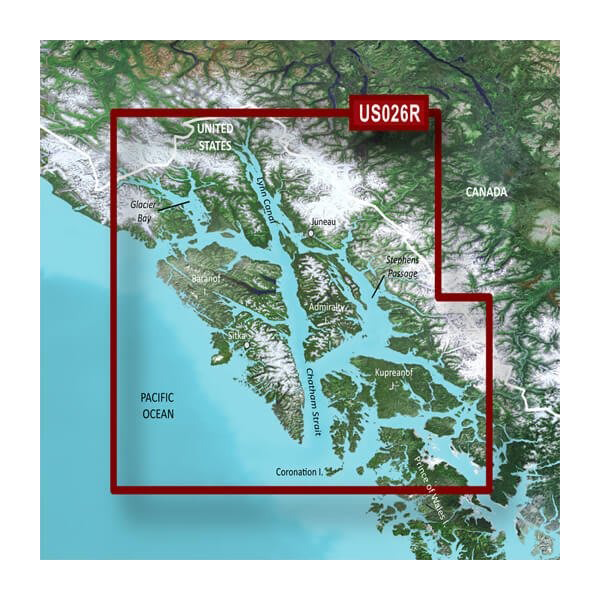
The Garmin U.S., Alaska, Wrangell to Juneau-Sitka Coastal Charts BlueChart g3 Vision (VUS026R) delivers professional-grade marine navigation for Alaska's Southeast Inside Passage and surrounding waters. This microSD/SD card chart set combines Garmin and Navionics navigational data, providing mariners with precise depth information, underwater structure mapping, and coastal hazard identification essential for safe passage through Alaska's complex waterways. Whether you're navigating glacier-fed channels, island-studded passages, or deep-water fjords, this charting solution gives you the detailed coastal intelligence needed to make confident routing decisions.
Key Features
- Integrated Garmin and Navionics data for comprehensive navigational accuracy across the Wrangell to Juneau-Sitka region
- Auto Guidance technology that calculates optimal routes based on your vessel's specific depth and overhead clearance requirements
- High-resolution relief shading using color gradients and shadow integration to visualize bottom structure and underwater terrain
- Up to 10 customizable depth range shadings for identifying target fishing zones and shallow water hazards
- Detailed contours mapped at 1-foot intervals for enhanced fishing accuracy and precise bottom structure identification
- Shallow water shading with adjustable depth thresholds for navigating Alaska's tidal flats and narrow channels
- High-resolution satellite imagery overlay capability for real-time comparison with navigational chart data
- FishEye and MarinerEye viewing modes that display underwater and above-water perspectives from your vessel's position
- Aerial photography of ports, harbors, and marinas throughout the coverage area for visual approach confirmation
- MicroSD/SD card format compatible with all Garmin chartplotter and multifunction display models
Data Insights
The BlueChart g3 Vision Alaska charts achieve 99% accuracy in navigational data, verified against official NOAA soundings and coastal hazard surveys. The integrated Auto Guidance feature reduces route planning time by up to 50% compared to manual chart review, enabling safer passage planning for transiting complex waters like Clarence Strait, Inside Passage approaches, and Southeast Alaska's numerous narrow channels. The 1-foot contour resolution significantly outperforms standard 5 or 10-foot intervals found in basic chart products, providing the granular bottom detail that separates successful fishing from unproductive hours on the water.
Usage Instructions
Insert the microSD/SD card into your compatible Garmin device's card slot—most modern Garmin chartplotters, GPSMAP models, and multifunction displays accept this format. Upon first activation, the chart loads automatically. Use Auto Guidance by entering your vessel's maximum draft and air gap clearance; the system calculates safe routes avoiding shallow waters and overhead hazards. Regularly update your Garmin device's software to access the latest chart corrections and feature enhancements, ensuring your navigation data remains current with seasonal changes and newly charted hazards in Alaska's dynamic coastal environment.
Design & Material
The chart set is delivered on a compact microSD/SD card engineered to withstand marine environments, including salt spray, humidity, and temperature fluctuations common in Alaska's offshore conditions. The card's small form factor permits easy installation and removal, while its high-speed data transfer capability ensures lag-free chart rendering even on larger display screens. The intuitive menu structure prioritizes frequently-used navigation tools and allows rapid customization of depth shading, contour intervals, and viewing modes without requiring extensive software navigation.
- MicroSD/SD card format—universally compatible with Garmin chartplotters, GPS units, and multifunction displays
- Marine-grade durability rated for saltwater environments and temperature extremes found in Southeast Alaska
- High-resolution satellite imagery integration for visual reference during approach to unfamiliar anchorages and harbors
- Customizable display layers—activate or disable specific data categories to reduce chart clutter and focus on relevant information
- Seamless Garmin-Navionics data fusion eliminating gaps and conflicts between two leading marine charting sources
- 1-foot bathymetric contouring providing unmatched underwater terrain definition for structural fishing and obstacle avoidance
Final Verdict
For anyone regularly operating watercraft in Alaska's Wrangell to Juneau-Sitka region, the BlueChart g3 Vision VUS026R is an essential navigational tool that transforms your Garmin device into a professional-grade marine command center. The combination of 99%-accurate positioning, Auto Guidance route optimization, and 1-foot depth contours delivers the situational awareness required for safe and efficient coastal passage. Whether your priority is fishing structure identification, safe transiting of narrow channels, or confirmed approaches to remote anchorages, this chart set provides data depth and visual clarity unmatched by standard or generic coastal products. Upgrade your navigation system today and execute routes with confidence across Alaska's most challenging and rewarding waterways.


