


Garmin U.S., Maine, North Coastal Charts BlueChart g3 Vision | VUS001R | microSD/SD
Garmin U.S., Maine, North Coastal Charts BlueChart g3 Vision | VUS001R | microSD/SD
Model Number: 010-C0702-00
In stock
 WhatsApp
 SMS - Text us!
 Email Us!
 Help Desk

Tech Specs

In The Box
Do you have an old GPS unit lying around? The GPS Nation Trade In and Up program is a great way to trade in your old and used GPS for credit towards a new GPS. The choice is entirely yours! We’ve made the process simple and streamlined. Follow these simple steps, and you will be on your way to receiving credit towards your brand new GPS!
1. Get a quote
To get your free quote, provide your GPS type, manufacturer, model, and condition. Within 24 hours, you will receive a quote for the trade-in value of your current product. The GPS trade-in/trade-up form is at the bottom of this page.
2. Ship your product(s) for trade
After accepting our offer, pack your product(s) safely and ship them to us using the pre-paid shipping label provided to you. We will provide a confirmation email when your trade-in arrives at our warehouse. You have 30 days from the date you complete your on-line trade to ship the product to GPS Nation.
3. Make your purchase
Once we receive your product at our warehouse and we validate the stated condition, we will send you a confirmation email. If you elect to receive credit towards a new GPS at gpsnation.com, your store credit will be issued, and you are free to make your purchase.
Manual & Warranty
 Garmin Warranty
Reviews
Ask a Question
Tech Specs
In The Box
Trade-In
Do you have an old GPS unit lying around? The GPS Nation Trade In and Up program is a great way to trade in your old and used GPS for credit towards a new GPS. The choice is entirely yours! We’ve made the process simple and streamlined. Follow these simple steps, and you will be on your way to receiving credit towards your brand new GPS!
1. Get a quote
To get your free quote, provide your GPS type, manufacturer, model, and condition. Within 24 hours, you will receive a quote for the trade-in value of your current product. The GPS trade-in/trade-up form is at the bottom of this page.
2. Ship your product(s) for trade
After accepting our offer, pack your product(s) safely and ship them to us using the pre-paid shipping label provided to you. We will provide a confirmation email when your trade-in arrives at our warehouse. You have 30 days from the date you complete your on-line trade to ship the product to GPS Nation.
3. Make your purchase
Once we receive your product at our warehouse and we validate the stated condition, we will send you a confirmation email. If you elect to receive credit towards a new GPS at gpsnation.com, your store credit will be issued, and you are free to make your purchase.
Manual & Warranty
Overview
Garmin BlueChart g3 Vision Maine North Coastal Charts | VUS001R | microSD/SD Card
Introduction
The Garmin BlueChart g3 Vision VUS001R is a pre-programmed microSD/SD card that delivers high-resolution marine navigation charts for Maine's northern coastal waters, from Calais to Camden. This mapping solution combines Garmin and Navionics data to provide mariners with 90% accuracy in underwater topography, enabling confident navigation through complex waterways, rocky outcrops, and shallow passages that define this region. Unlike standard paper charts or generic mapping software, this card integrates satellite imagery, precise contour data, and real-time depth intelligence specifically engineered for the challenges of Maine's rugged coastline.
Key Features
- High-resolution satellite imagery with true 3D views supporting both FishEye and MarinerEye perspective modes
- Auto Guidance Technology that calculates optimal routes based on your vessel's draft and clearance requirements
- Depth range shading across 10 customizable ranges for immediate visual identification of safe water depths
- 1-foot contour intervals ideal for both commercial fishing operations and recreational angling in shallow coastal zones
- Shallow water shading with adjustable threshold settings to clearly highlight areas requiring caution
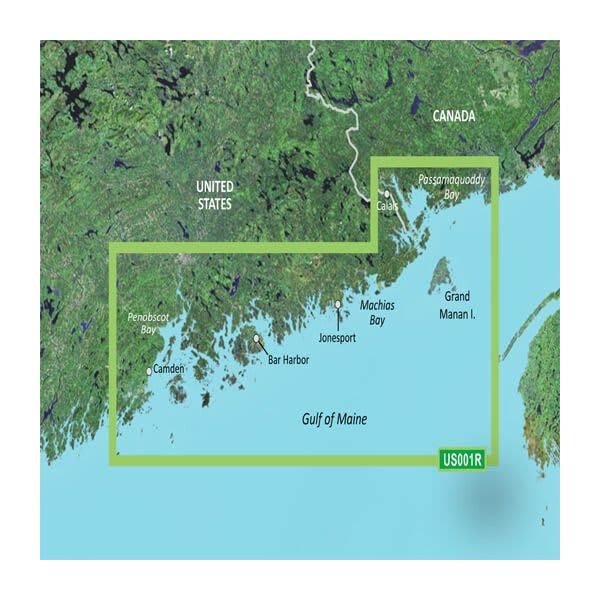
- Complete geographic coverage spanning from Calais to Camden, including Bar Harbor and major river systems
- Seamless integration with Garmin chartplotters via microSD/SD card compatibility
Data Insights
Garmin's BlueChart g3 Vision technology achieves 90% accuracy in underwater mapping and bathymetric visualization, significantly outperforming basic nautical charts by providing dynamic depth readings and contour precision. The integration of satellite imagery with detailed NOAA cartography produces a layered navigation environment where mariners can reference relief shading, bottom structure interpretation, and hazard zones simultaneously—critical advantages when navigating Maine's rocky shelves, ledges, and shipping channels where accurate depth data directly impacts safety and fishing success.
Usage Instructions
Insert the pre-programmed microSD/SD card into your compatible Garmin chartplotter and verify that the latest software updates are installed on your device. Access the chart settings menu and enable the Auto Guidance feature, then input your vessel's maximum draft and desired safety clearance. The card will immediately calculate optimal routes through your chosen destination. Activate depth range shading and contour display for real-time situational awareness while underway through Maine's coastal passages.
Design & Material
The BlueChart g3 Vision is engineered as a durable, pre-programmed storage card that eliminates installation complexity while ensuring rapid deployment on compatible Garmin marine electronics. Its streamlined design prioritizes functionality over form, focusing on delivering dense cartographic information with intuitive visual hierarchies.
- Durable microSD/SD card construction rated for marine environments with reliable long-term data integrity
- Pre-programmed with complete Maine North Coastal chart data; no additional downloading or configuration required
- High-resolution satellite imagery providing realistic contextual reference for navigation and waypoint selection
- FishEye 3D perspective enables mariners to visualize underwater terrain and structures from multiple angles
- MarinerEye surface-level visualization supports tactical navigation through narrow channels and harbor approaches
- Advanced relief shading and color-coded depth representation enhance rapid comprehension of bottom topology and hazards
Final Verdict
The Garmin BlueChart g3 Vision VUS001R is purpose-built for mariners operating in Maine's challenging northern coastal environment. Its 90% underwater mapping accuracy, 1-foot contour detail, and integrated satellite imagery provide the precision and confidence required for safe passage through rocky waters, productive fishing grounds, and narrow anchorages. Whether navigating to Bar Harbor, threading through island passages, or fishing shallow river mouths along the coast, this card delivers navigation intelligence that standard charts cannot match. Insert it into your Garmin chartplotter and navigate Maine's coast with professional-grade cartographic authority.


