

Garmin Worldwide Coastal Charts BlueChart g3 HXWW001G microSD/SD (010-C1137-20)
Garmin Worldwide Coastal Charts BlueChart g3 HXWW001G microSD/SD (010-C1137-20)
Model Number: 010-C1137-20
Low stock
 WhatsApp
 SMS - Text us!
 Email Us!
 Help Desk
Tech Specs
Garmin BlueChart g3 HXWW001G Worldwide Coastal Charts microSD/SD Card
Introduction
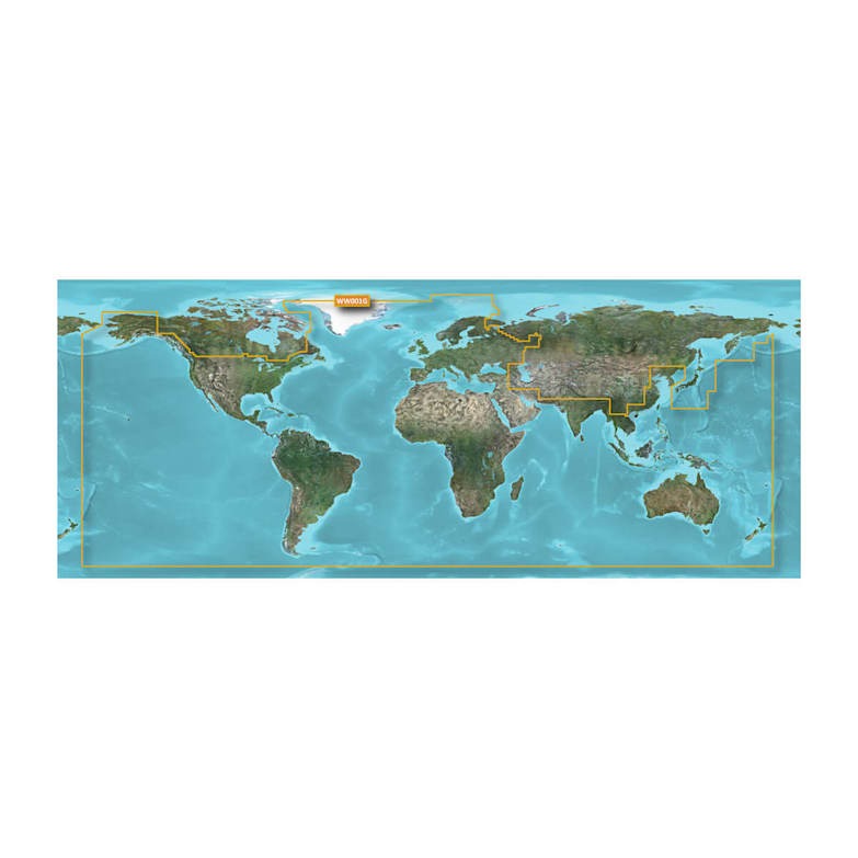
The Garmin BlueChart g3 HXWW001G Worldwide Coastal Charts microSD/SD card delivers comprehensive global coastal mapping data directly to your compatible Garmin chartplotter. This digital chart solution combines official hydrographic sources with trusted private data providers to create navigational tools that reduce guesswork and improve decision-making during every voyage. Whether you operate in home waters or explore unfamiliar coastlines, BlueChart g3 provides the marine-specific detail needed for safer harbor approaches, more efficient route planning, and better situational awareness across open water and confined passages alike.
Key Features
- Worldwide coastal chart coverage across all major ocean regions and navigable waterways
- Detailed depth contours and spot soundings for identifying channels, shoals, and underwater navigation hazards
- Tides and currents data integrated into chart display for current-aware voyage planning
- Shallow water shading with user-defined depth threshold settings for real-time hazard visualization
- Complete harbor and marina directory with approach details, anchorages, and facility information
- Comprehensive navigational aid display including buoys, lights, waypoints, and marine landmarks across all charted regions
Data Insights
BlueChart g3 addresses the critical navigation challenge of operating in unfamiliar waters by combining detailed depth mapping with real-time tidal and current information. The shallow water shading feature allows you to establish custom depth thresholds that visually highlight zones matching your vessel's draft, significantly improving hazard awareness in coastal and nearshore environments. Access to official harbor data eliminates the trial-and-error approach to port entry, while spot soundings and contour detail provide the underwater picture needed to understand why particular routes offer safer passage than others.
Usage Instructions
Insert the microSD/SD card into your compatible Garmin chartplotter's memory card slot following your device manual. Once recognized, navigate to chart settings within the chartplotter menu to customize display options including depth shading ranges, chart overlays, and information layers. Use the included chart data during pre-voyage route planning to identify hazards and plan efficient passages, monitor depth and navigation aids during operation, and reference harbor approaches and marina locations when entering unfamiliar ports. Always verify navigation information against current official sources and follow safe boating practices appropriate to your vessel and operating environment.
Design & Material
The BlueChart g3 HXWW001G ships as a compact microSD/SD memory card engineered for plug-and-play compatibility with Garmin's marine chartplotter ecosystem. The format provides instant access to advanced mapping features without requiring software installation or configuration beyond basic menu adjustments on your chartplotter display.
- microSD/SD memory card form factor for straightforward installation in any compatible Garmin chartplotter
- Chart data derived from official international hydrographic sources and established private marine data providers
- Detailed cartography including bottom composition, wrecks, underwater structures, and hazard markers
- Integrated tidal station information and current prediction data where available across charted regions
- Marina and harbor database with facility amenities, services, approach routes, and anchorage details
- Customizable shallow water shading that highlights user-selected depth ranges for enhanced hazard awareness
Final Verdict
The Garmin BlueChart g3 HXWW001G is the navigation solution for boaters who demand reliable, detailed marine chart information across global waters. By combining official hydrographic data with tidal information, depth detail, and comprehensive harbor knowledge, it transforms your Garmin chartplotter into a fully capable offshore and coastal navigation system. If you cruise beyond home waters, operate in unfamiliar regions, or prioritize navigation confidence and route efficiency, this chart card provides the essential information depth and coverage your boating demands. Order your BlueChart g3 HXWW001G today to access worldwide coastal navigation at your fingertips.
In The Box
Do you have an old GPS unit lying around? The GPS Nation Trade In and Up program is a great way to trade in your old and used GPS for credit towards a new GPS. The choice is entirely yours! We’ve made the process simple and streamlined. Follow these simple steps, and you will be on your way to receiving credit towards your brand new GPS!
1. Get a quote
To get your free quote, provide your GPS type, manufacturer, model, and condition. Within 24 hours, you will receive a quote for the trade-in value of your current product. The GPS trade-in/trade-up form is at the bottom of this page.
2. Ship your product(s) for trade
After accepting our offer, pack your product(s) safely and ship them to us using the pre-paid shipping label provided to you. We will provide a confirmation email when your trade-in arrives at our warehouse. You have 30 days from the date you complete your on-line trade to ship the product to GPS Nation.
3. Make your purchase
Once we receive your product at our warehouse and we validate the stated condition, we will send you a confirmation email. If you elect to receive credit towards a new GPS at gpsnation.com, your store credit will be issued, and you are free to make your purchase.
Manual & Warranty
Reviews
Ask a Question
Tech Specs
Garmin BlueChart g3 HXWW001G Worldwide Coastal Charts microSD/SD Card
Introduction
The Garmin BlueChart g3 HXWW001G Worldwide Coastal Charts microSD/SD card delivers comprehensive global coastal mapping data directly to your compatible Garmin chartplotter. This digital chart solution combines official hydrographic sources with trusted private data providers to create navigational tools that reduce guesswork and improve decision-making during every voyage. Whether you operate in home waters or explore unfamiliar coastlines, BlueChart g3 provides the marine-specific detail needed for safer harbor approaches, more efficient route planning, and better situational awareness across open water and confined passages alike.
Key Features
- Worldwide coastal chart coverage across all major ocean regions and navigable waterways
- Detailed depth contours and spot soundings for identifying channels, shoals, and underwater navigation hazards
- Tides and currents data integrated into chart display for current-aware voyage planning
- Shallow water shading with user-defined depth threshold settings for real-time hazard visualization
- Complete harbor and marina directory with approach details, anchorages, and facility information
- Comprehensive navigational aid display including buoys, lights, waypoints, and marine landmarks across all charted regions
Data Insights
BlueChart g3 addresses the critical navigation challenge of operating in unfamiliar waters by combining detailed depth mapping with real-time tidal and current information. The shallow water shading feature allows you to establish custom depth thresholds that visually highlight zones matching your vessel's draft, significantly improving hazard awareness in coastal and nearshore environments. Access to official harbor data eliminates the trial-and-error approach to port entry, while spot soundings and contour detail provide the underwater picture needed to understand why particular routes offer safer passage than others.
Usage Instructions
Insert the microSD/SD card into your compatible Garmin chartplotter's memory card slot following your device manual. Once recognized, navigate to chart settings within the chartplotter menu to customize display options including depth shading ranges, chart overlays, and information layers. Use the included chart data during pre-voyage route planning to identify hazards and plan efficient passages, monitor depth and navigation aids during operation, and reference harbor approaches and marina locations when entering unfamiliar ports. Always verify navigation information against current official sources and follow safe boating practices appropriate to your vessel and operating environment.
Design & Material
The BlueChart g3 HXWW001G ships as a compact microSD/SD memory card engineered for plug-and-play compatibility with Garmin's marine chartplotter ecosystem. The format provides instant access to advanced mapping features without requiring software installation or configuration beyond basic menu adjustments on your chartplotter display.
- microSD/SD memory card form factor for straightforward installation in any compatible Garmin chartplotter
- Chart data derived from official international hydrographic sources and established private marine data providers
- Detailed cartography including bottom composition, wrecks, underwater structures, and hazard markers
- Integrated tidal station information and current prediction data where available across charted regions
- Marina and harbor database with facility amenities, services, approach routes, and anchorage details
- Customizable shallow water shading that highlights user-selected depth ranges for enhanced hazard awareness
Final Verdict
The Garmin BlueChart g3 HXWW001G is the navigation solution for boaters who demand reliable, detailed marine chart information across global waters. By combining official hydrographic data with tidal information, depth detail, and comprehensive harbor knowledge, it transforms your Garmin chartplotter into a fully capable offshore and coastal navigation system. If you cruise beyond home waters, operate in unfamiliar regions, or prioritize navigation confidence and route efficiency, this chart card provides the essential information depth and coverage your boating demands. Order your BlueChart g3 HXWW001G today to access worldwide coastal navigation at your fingertips.
In The Box
Trade-In
Do you have an old GPS unit lying around? The GPS Nation Trade In and Up program is a great way to trade in your old and used GPS for credit towards a new GPS. The choice is entirely yours! We’ve made the process simple and streamlined. Follow these simple steps, and you will be on your way to receiving credit towards your brand new GPS!
1. Get a quote
To get your free quote, provide your GPS type, manufacturer, model, and condition. Within 24 hours, you will receive a quote for the trade-in value of your current product. The GPS trade-in/trade-up form is at the bottom of this page.
2. Ship your product(s) for trade
After accepting our offer, pack your product(s) safely and ship them to us using the pre-paid shipping label provided to you. We will provide a confirmation email when your trade-in arrives at our warehouse. You have 30 days from the date you complete your on-line trade to ship the product to GPS Nation.
3. Make your purchase
Once we receive your product at our warehouse and we validate the stated condition, we will send you a confirmation email. If you elect to receive credit towards a new GPS at gpsnation.com, your store credit will be issued, and you are free to make your purchase.
Manual & Warranty
Overview
Garmin BlueChart g3 HXWW001G Worldwide Coastal Charts microSD/SD Card
Introduction
The Garmin BlueChart g3 HXWW001G Worldwide Coastal Charts microSD/SD card delivers comprehensive global coastal mapping data directly to your compatible Garmin chartplotter. This digital chart solution combines official hydrographic sources with trusted private data providers to create navigational tools that reduce guesswork and improve decision-making during every voyage. Whether you operate in home waters or explore unfamiliar coastlines, BlueChart g3 provides the marine-specific detail needed for safer harbor approaches, more efficient route planning, and better situational awareness across open water and confined passages alike.
Key Features
- Worldwide coastal chart coverage across all major ocean regions and navigable waterways
- Detailed depth contours and spot soundings for identifying channels, shoals, and underwater navigation hazards
- Tides and currents data integrated into chart display for current-aware voyage planning
- Shallow water shading with user-defined depth threshold settings for real-time hazard visualization
- Complete harbor and marina directory with approach details, anchorages, and facility information
- Comprehensive navigational aid display including buoys, lights, waypoints, and marine landmarks across all charted regions
Data Insights
BlueChart g3 addresses the critical navigation challenge of operating in unfamiliar waters by combining detailed depth mapping with real-time tidal and current information. The shallow water shading feature allows you to establish custom depth thresholds that visually highlight zones matching your vessel's draft, significantly improving hazard awareness in coastal and nearshore environments. Access to official harbor data eliminates the trial-and-error approach to port entry, while spot soundings and contour detail provide the underwater picture needed to understand why particular routes offer safer passage than others.
Usage Instructions
Insert the microSD/SD card into your compatible Garmin chartplotter's memory card slot following your device manual. Once recognized, navigate to chart settings within the chartplotter menu to customize display options including depth shading ranges, chart overlays, and information layers. Use the included chart data during pre-voyage route planning to identify hazards and plan efficient passages, monitor depth and navigation aids during operation, and reference harbor approaches and marina locations when entering unfamiliar ports. Always verify navigation information against current official sources and follow safe boating practices appropriate to your vessel and operating environment.
Design & Material
The BlueChart g3 HXWW001G ships as a compact microSD/SD memory card engineered for plug-and-play compatibility with Garmin's marine chartplotter ecosystem. The format provides instant access to advanced mapping features without requiring software installation or configuration beyond basic menu adjustments on your chartplotter display.
- microSD/SD memory card form factor for straightforward installation in any compatible Garmin chartplotter
- Chart data derived from official international hydrographic sources and established private marine data providers
- Detailed cartography including bottom composition, wrecks, underwater structures, and hazard markers
- Integrated tidal station information and current prediction data where available across charted regions
- Marina and harbor database with facility amenities, services, approach routes, and anchorage details
- Customizable shallow water shading that highlights user-selected depth ranges for enhanced hazard awareness
Final Verdict
The Garmin BlueChart g3 HXWW001G is the navigation solution for boaters who demand reliable, detailed marine chart information across global waters. By combining official hydrographic data with tidal information, depth detail, and comprehensive harbor knowledge, it transforms your Garmin chartplotter into a fully capable offshore and coastal navigation system. If you cruise beyond home waters, operate in unfamiliar regions, or prioritize navigation confidence and route efficiency, this chart card provides the essential information depth and coverage your boating demands. Order your BlueChart g3 HXWW001G today to access worldwide coastal navigation at your fingertips.


